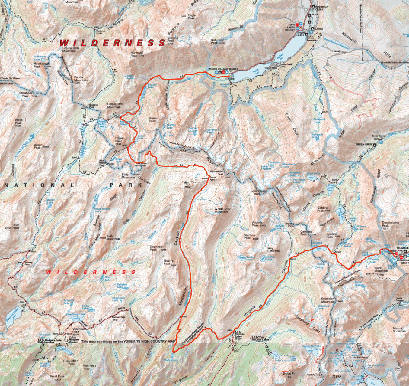
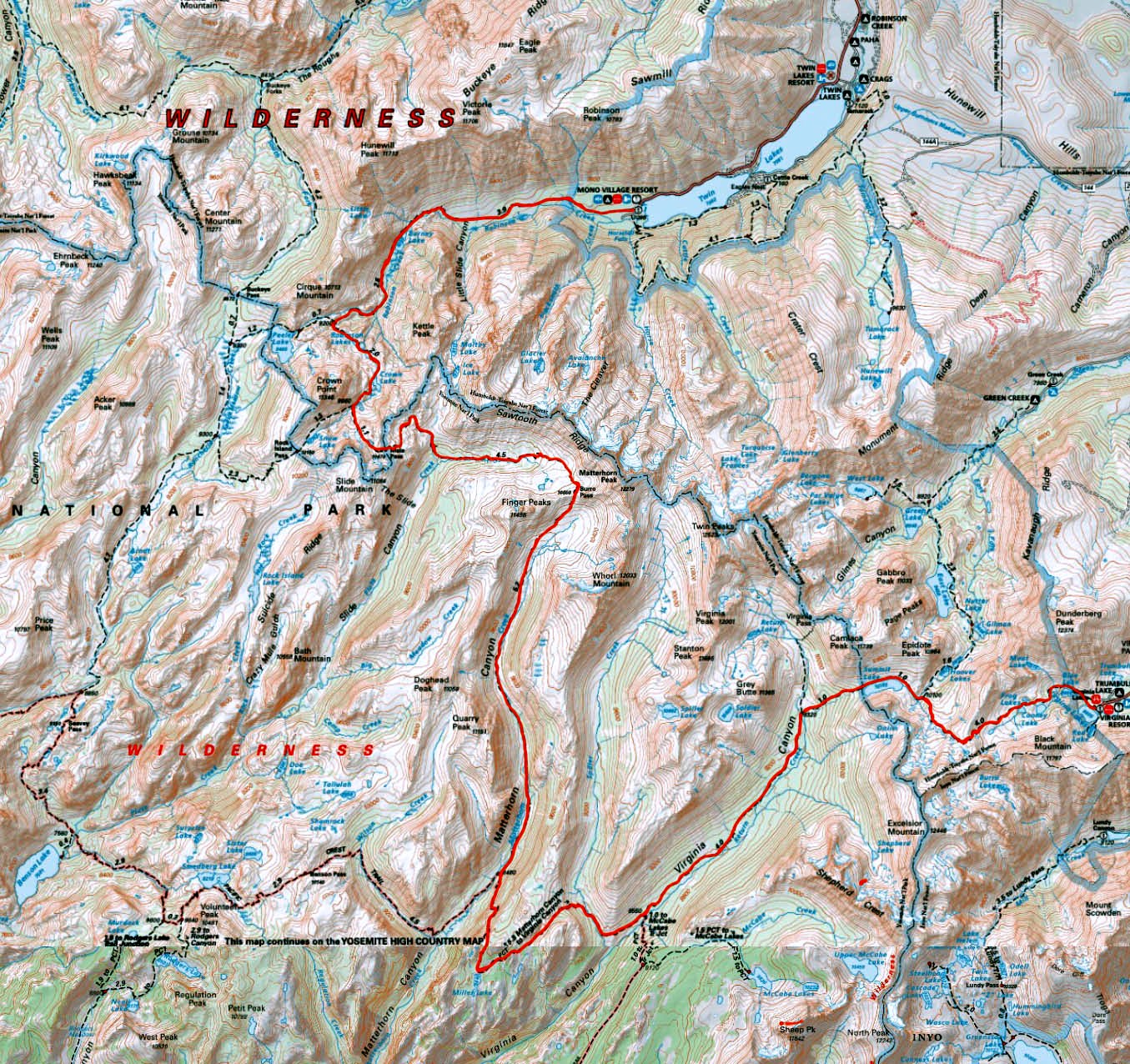
Trip Overview:
This trip takes you through a beautiful, remote section of Yosemite National Park. You will enter Yosemite from the east side of the Sierra, at Virginia Lakes, to cross the Sierra Crest into Yosemite National Park. Your path will lead you past towering granite peaks, cascading creeks, sparkling lakes, and lush meadows as you walk down Virginia Canyon, up picturesque Matterhorn Canyon, over scenic Burro Pass, along the base of Sawtooth Ridge, over Mule Pass, and past dramatic Crown Point as you leave the backcountry to Twin Lakes. Most of the days are relatively short with elevation gains typically less than 1,500, so this is a perfect trip for someone new to hiking the backcountry with pack stock. This is a trip to take slowly to better enjoy the beautiful scenery between the camps.
Arrive at Virginia Lakes Pack Outfit by 7:00 AM where your gear will be weighed and you will be served a hearty breakfast. Your personal vehicles will be left in the pack station parking area.
Begin at Virginia Lakes; Ending at Mono Village, Twin Lakes.
You will be ferried the one mile from the pack station to the trailhead. The pack station will pick you up at the entrance to Mono Village Campground, returning you to the Virginia Lakes Pack Outfit station.
Hikers should be able to walk eight miles, 1,500 elevation gain and 2,500 loss. You should acclimate to 8,000 to 10,000 for 1-3 days prior to the trip.
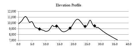
Distance: 36 miles with a total gain of 6,450 feet, and a total loss of 9,200 feet.
Elevation Profile:
GENERAL:This trip passes many lakes and creeks, so available drinking water is not a problem in normal water conditions. Be prepared for numerous creek crossings. Most of the crossings can be made on rocks or logs.
Day 1: Virginia Lakes to Virginia Canyon
7.7 miles, 1,450 gain, 2,350 loss
The trail follows the north side of Blue Lake and then climbs fairly steeply in open forest to Cooney Lake in the first mile. The trail climbs 750 past the Frog Lakes on shale slopes to a saddle at mile 2.6. The rocky path descends steeply to the Green Lake Trail junction at mile four. Turn left at the junction toward Summit Lake and climb 170 in 0.4 miles to the lake. The trail drops steeply as it enters Yosemite National Park, turning into a gentle descent down through Virginia Canyon after the junction to Virginia Pass. The path down the canyon is through lodgepoles and meadows, with areas of trees downed by avalanches during high snow years. Camp is about 1.7 miles down canyon from the Virginia Pass junction.
Day 2: Virginia Canyon to Miller Lake
6.2 miles, 1,350 gain, 800 loss
A gentle descent down Virginia Canyon to the junction of the Pacific Crest Trail at mile 2.3. The trail to the right continues down the canyon before climbing 1,000 fairly steeply up Spiller Creek and finally up to a saddle at mile 4.6. Wonderful views to the west open up as the trail undulates another 1.4 miles to Miller Lake. Camp is another 0.2 miles along the west shore of the lake. The lake is shallow which makes it a good swimming lake. There are wonderful views across the canyon of the Tuolumne River as far as the Cathedral Range to the south from near the outlet of the lake or the low dome to the west of the lake.
Day 3: Miller Lake to Upper Matterhorn Canyon
4.9 miles, 850 gain, 1,200 loss
The trail leaves Miller Lake to cross a wide meadow to a wonderful view of the mountains surrounding upper Matterhorn Canyon. The path then switchbacks down through the forest before bottoming out in Matterhorn Canyon and the junction to Burro Pass at mile 2.3. Leaving the Pacific Crest Trail toward Burro Pass, the trail follows the stream through open pine forest, which eventually thins to open meadow as the path climbs up toward Burro Pass. There are typically a number of stream crossings and damp meadows under normal water conditions. Camp will be at 9,100 on the left side of the trail about ½ mile past Quarry Peak.
Day 4: Matterhorn Canyon over Burro Pass to Slide Canyon
5.5 miles, 1,550; gain, 1,300 loss
The path follows the canyon, climbing steadily toward 10,650 Burro Pass with Finger Peaks on the left and Matterhorn Peak on the right. The trail becomes steep and rocky for the last 400 to the pass, mile 2.6. Rocky switchbacks lead down to alpine meadows and then into open forest as the trail follows Piute Creek to Slide Canyon, some 1,300 below Burro Pass. Slide Canyon Camp is at 9,500 to the left as the trail bottoms out below Mule Pass.
The relatively short move allows time to enjoy the stunning views of Sawtooth Ridge from Burro Pass and the series of meadows below the pass. You could also visit Slide Canyon with a slide of car-size boulders at the base of the 1,600 wall the rock avalanche fell from. The slide is about 0.7 mile and 250 down from camp, although the walk was made more difficult a few years ago with trees felled by high winds.
Day 5: Slide Canyon over Mule Pass to Crown Lake
3.4 miles, 1,100 gain, 1,000 loss
The trail starts up toward Mule Pass through forest, switchbacking near a small branch of Piute Creek, with some views of the Slide, before coming out of the canyon to a subalpine bench and into a rocky gulch with some great vistas toward Burro Pass. The final ascent of 10,470 Mule Pass is a sometimes steep, rocky trail, mile 1.7. The path leaves Yosemite National Park at the pass, dropping 800 in 1.4 miles down through some pocket meadows and sometimes steep rocky switchbacks to the Rock Island Pass junction. We turn right toward Robinson Lakes and descend to 9,500 Crown Lake, our last camp.
This is a short day, so consider a side trip to Snow Lake, Rock Island Pass, or Rock Island Lake. The trail leaves the 9,660 Robinson Lakes/Rock Island Pass Junction climbing to 10,200 in ½ mile before dropping down to 10,117 Snow Lake. The 10,150 Rock Island Pass is 1.3 miles from the junction. For those who cross country, leave the trail below the pass, contouring to a ridge to the south to look down on Rock Island Lake, about two miles from the junction. Another mile and dropping an additional 1,300 would take you to the 9,831 lake. Return along the same route.
Day 6: Crown Lake to Twin Lakes
8.3 miles, 150 gain, 2,500 loss
The trail drops 300 through a pine forest to the Robinson Lakes and then undulates through the blocky terminal moraine of the Crown Point cirque glacier to the Peeler Lake junction, mile 1.3. Turning toward Twin Lakes, the trail drops 1,000 through forest toward Barney Lake. The path leaves the forest to contour along the dry talus slope above the swampy area upstream of the lake, eventually dropping down to a perfect lunch break at the beautiful lake at mile 3.9. The trail drops steadily in and out of an aspen forest and then along a treeless stretch, which is compensated by a panorama of the Sawtooth Range and other named peaks. The trail reenters the forest to end at the Mono Village campground. Walk through the campground to the entrance where you will find your packers unloading your gear. Plan to meet the pack station driver at 2:00 to return to the Virginia Lakes Pack Outfit station.
| Location | Daily
Distance | Cumulative
Distance | Elevation |
| Virginia Lakes | | 0.0 | 9,836
| | Cooney Lake | | 1.0 | 10,247
| | Frog Lakes Outlet | | 1.2 | 10,359
| | Ridge | | 2.6 | 11,120
| | Hoover Lakes Junction | | 4.0 | 10,100
| | East end Summit Lake | | 4.4 | 10,200
| | Yosemite National Park Boundary | | 5.0 | 10,183
| | Virginia Pass Junction | | 6.0 | 9,320
| | Table Camp | 7.7 | 7.7 | 8,965
| | PCT Junction | | 10.0 | 8,550
| | Stream Crossing | | 11.1 | 8,768
| | Ridge | | 12.3 | 9,573
| | Meadow by Hook Lake | | 12.8 | 9,386
| | Miller Lake | | 13.7 | 9,475
| | Miller Lake Camp | 6.2 | 13.9 | 9,450
| | Return to Trail | | 14.1 | 9,475
| | Burro Pass Junction | | 16.2 | 8,480
| | Matterhorn Camp | 4.9 | 18.8 | 9,113
| | Burro Pass | | 21.4 | 10,650
| | Slide Canyon Camp | 5.5 | 24.2 | 9,378
| | Mule Pass | | 25.9 | 10,470
| | Mdw and Lake | | 26.4 | 10,315
| | Rock Island Pass Jct | | 27.0 | 9,660
| | Crown Lake Outlet | 3.4 | 27.7 | 9,484
| | Between Robinson Lakes | | 28.4 | 9,192
| | Ridge | | 28.7 | 9,261
| | Peeler Lake Jct | | 29.0 | 9,200
| | Barney Lake | | 31.6 | 8,265
| | Twin Lakes Camp Cable | | 35.7 | 7,135
| | Campground Entrance | 8.3 | 36.0 | 7,098
|
Please note that this represents the planned itinerary. Weather or other factors may affect the choice of campsites and daily travel. All decisions are made by the Head Packer with attention to the safety and comfort of guests and stock.
Expected Campsite Locations
| Day | To | Elevation | Latitude N | Longitude W | Miles | Gain | Loss |
| 1 | Virginia Canyon | 8,950 | 38.026 | 119.348 | 7.7 | 1,450 | 2,350 |
| 2 | Miller Lake | 9,450 | 37.991 | 119.420 | 6.2 | 1,350 | 800
| | 3 | Upper Matterhorn Canyon | 9,100 | 38.054 | 119.414 | 4.9 | 850 | 1,200 |
| 4 | Slide Canyon | 9,400 | 38.097 | 119.428 | 5.5 | 1,550 | 1,300
| | 5 | Crown Lake | 9,500 | 38.115 | 119.444 | 3.4 | 1,100 | 1,000 |
| 6 | Twin Lakes | 7,100 | | | 8.3 | 150 | 2,550 |
| | Total | | | | 36.0 | 6,450 | 9,200 |
*Mileage, gain, and loss based on Guthooks PCT Guide.
PHOTOS...
more to come....
What you need to know
for hikers on pack stock supported trips
Dunnage limit is 30 lbs. per person (this includes sleeping bags, fishing equipment, liquor, etc.)
You may bring your own tent up to 10 pounds that is in addition. The PCT 28 day trip allows 35 pounds of duffel.
PERSONAL CHECK LIST
Bring belongings in stout canvas or nylon duffels; side zipper recommended, ideal size approximately 14" x 32". It is a good idea to use a large plastic bag INSIDE of the duffle to protect contents from external moisture.
Sleeping bags can be in separate duffels --again, line the inside of the duffle against rain.
Place all cosmetics, soaps, medications, etc into small plastic containers with close-fitting caps, THEN into sturdy resealable plastic storage bags. If anything breaks or bursts from altitude changes, the plastic bag contains the spill.
When possible, it is a good idea to transfer alcoholic beverages to sturdy plastic bottles with well fitting caps - it will save weight and protect against breakage.
ESSENTIALS
- Footwear. For this trips a medium-weight pair of hiking boots. We
do not recommend lightweight hikers or tennies since they give
little ankle support and the soles are often thin.
- Camp Shoes. A lightweight pair of tennies or Tevas to wear in
camp. This will reduce vegetation damage at our campsites.
- A day pack. It should be large enough to take water, extra clothing, rainwear,
camera, etc during the days.
- Sleeping Bag. Most summer trips are warm and a bag rated to
about 25°F will be plenty warm enough. We much prefer down
bags, and good quality ones at that. Your bag should weigh in
around 3 pounds.
- Sleeping pad. A 3/4 or full length closed cell foam or Thermarest.
If you bring a Thermarest also bring a repair kit to fix pesky holes!
- Coffee mug (plastic for camp)
CLOTHING
- 2 pair synthetic liner socks.
- 2 pair heavier synthetic or wool blend socks.
- Long underwear top. Capilene, some other synthetic or the new
pure Merino wool types.
- Long underwear bottom.
- Warm pants. Tights or Expedition Weight Capilene.
- Warm shirt. Synchilla or R2 weight works well.
- Another fuzzy sweater top or pile jacket of some sort
- GoreTex Jacket and Pants. A lightweight set is sufficient and heavy
bulky clothing is unnecessary. Side zips on the pants should be
long enough to slide over boots. Jacket must have a hood. Do not
skimp on your rain gear. Nylon ponchos are not acceptable.
- Shorts for on the trail
- Tee shirt for on the trail
- Lightweight capilene or similar gloves.
- Warm hat. Synthetic or wool.
- Sunhat
ETC.
- Sun glasses.
- Water Bottles. Two quart (1 liter) wide mouth bottles and/or a hydration
system holding up to 50oz. (2 liters). Dont bring bike bottles or
any bottle that doesnt have a wide opening.
- Headlamp. --and a spare set of batteries!
- Pocket knife. Swiss army style.
- Personal toiletries. It is not necessary to smell like a rose each day
so do not over do it.
- Ear plugs are great to have in a noisy tent.
- Personal Medical Kit. The guide will carry a large kit so yours will
predominately consist of foot repair items, mild pain killer such as
Advil and bandaids.
- Sunscreen and lip screen. SPF 30+. A 1oz. bottle will be enough.
Make sure the lip stuff actually contains a sunscreen.
- Bug repellent.
- Camera. A spare battery and card are good backups
- Ski/trekking poles. These are not essential, but can be handy on
the trail. It is your choice, but they do save wear on the knees.
- Plastic trash bag. Handy for keeping gear in outside the tent
should it rain.
- Optional reading material, etc.
FOOD
We provide the all meals on scheduled trips. You can bring
your favorite "on-the-trail" snacks.
OPTIONAL ITEMS
- Small notepad and pencil
- Collapsible plastic wash basin (optional)
- Solar shower (optional)
- Water filtering pump (optional)
- Liquor (be sure to check in with the packers to see that your liquor is packed safely)
- Fishing equipment (optional)
- Rod/reel/line (a rod that breaks down into 3 or more pieces is recommended)
- Compact metal rod case to carry on saddle
- Canvas creel (no tackle boxes)
- Leader material (1-3 lb.)
- Flies: black gnat, mosquito, grey hackle, brown hackle, & royal coachman (No. 12-14 hooks)
- Bait: worms & Pautzke red eggs
- Egg hooks, worm hooks (No. 10-14)
- Split shot
- Lures (personal choice)
- Pliers
TOM HARRISON MAPS. Tom Harrison Hoover Wilderness Map, paper or download onto phone/tablet. A short section of the trail missing from the map includes Miller Lake, which is on the Yosemite High Country map.
National Geographic 308 Yosemite NE: Tuolumne Meadows and Hoover Wilderness Trail Map.
Apps for Smartphone/Tablet, download applicable areas prior to departure:
Click on the map to see a larger version
|