Trip Overview:
This is an opportunity for singles, couples and small groups to join others on an open trip that allows you to hike to the top of Mt. Whitney. Hike only with a day pack…we provide the camp, food, equipment and all you need to bring is your sleeping bag, pad and personal items.
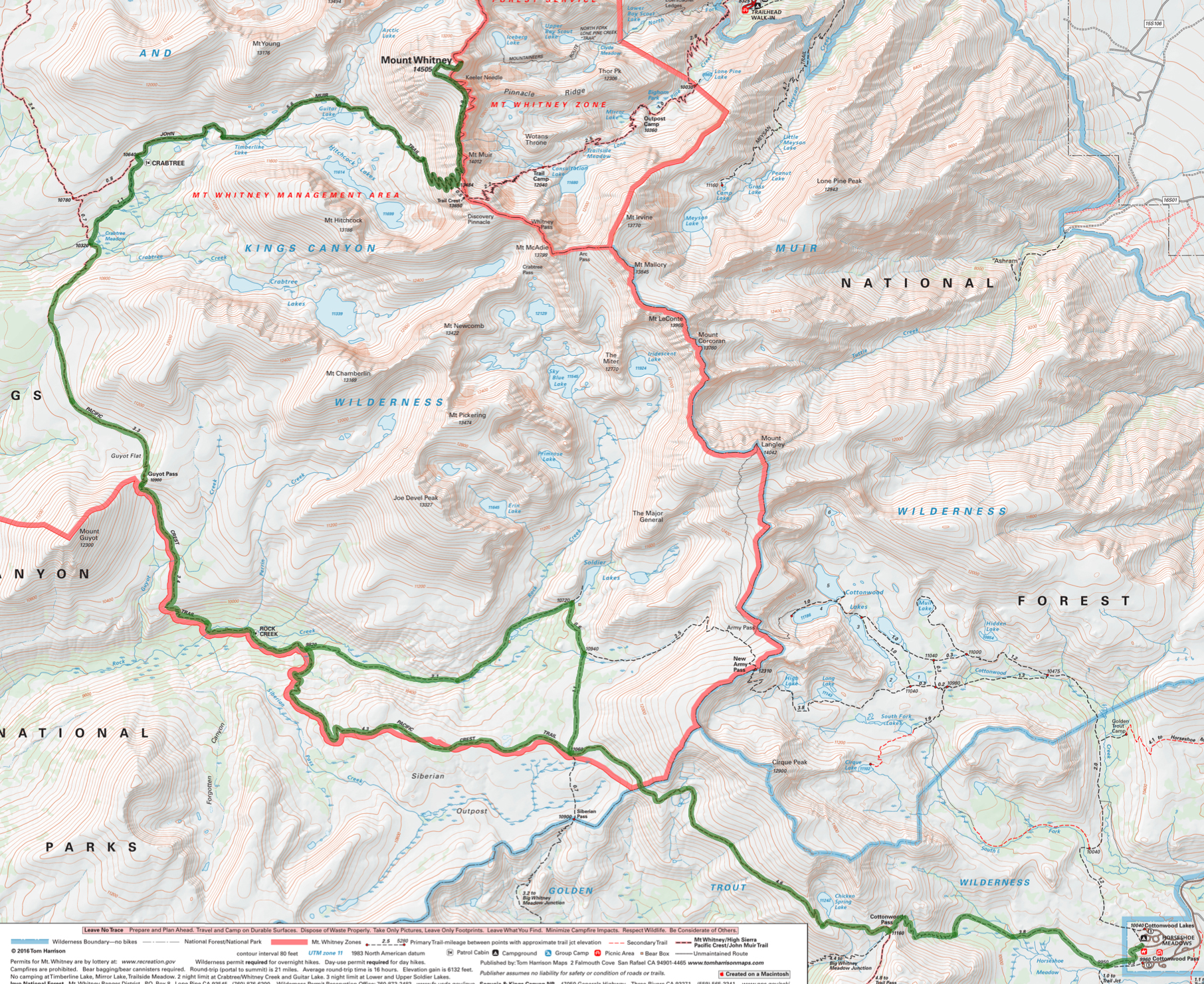
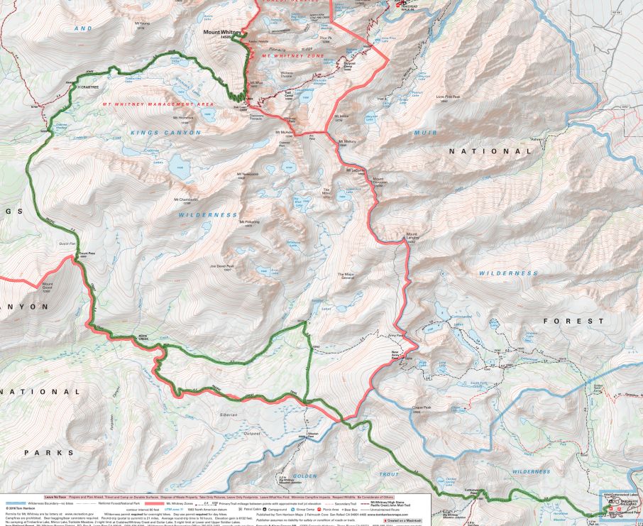
Summit Mount Whitney with a daypack and avoid the crowds and 6,100 gain and loss in 21.4 miles of the Whitney Portal trail. This trip takes you into the Sierra backcountry from Horseshoe Meadow. You will hike along a section of the Pacific Crest Trail to the west side of Mount Whitney, where you will walk up 3,000 from our camp at Guitar Lake to the Summit. An early start lets enjoy the expansive views from the top before the crowds arrive. Youll return to Horseshoe Meadow by way of beautiful Rock Creek.
The crew will furnish delicious meals with a cook to handle all the kitchen chores. Chairs are furnished to relax in camp. In case of rain, the wranglers will put up a large tarp to sit under. A sit-down toilet will be provided at each camp with a privacy tent. Mules will carry all equipment, food, and personal gear not needed for your day hikes along the PCT and to the top of Mount Whitney.
You will travel approximately 58 miles with a total gain and loss of 11,800 feet.
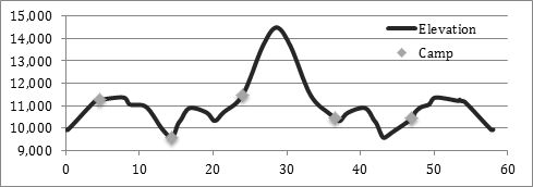
Hikers should be able to walk 12 miles, 4,000 elevation gain/loss.
This trip begins and ends at Horseshoe Meadows.
Arrive at the corrals next to the Cottonwood Pack Station by 7:00 AM where your gear will be weighed and you will be served breakfast. A sack lunch will be provided. Your personal vehicles will be left in the public parking area adjacent to the pack station.
The Golden Trout Info Link tells you how to get to Horseshoe Meadows and about trailhead camping and services.
Day 1: Horseshoe Meadow over Cottonwood Pass to Chicken Spring Lake
4.6 miles, 1,400 gain, 100 loss
The day will start at the corrals by the Cottonwood Pack Station. You will meet your crew, who will provide breakfast and a sack lunch while they weigh your gear. You will start your hike toward Chicken Spring Lake while the crew loads the mules. The walk begins as a gentle ascent beside the meadow for a mile before entering the open forest to climb steadily to 11,160 Cottonwood Pass by mile 3.8. Turn north onto the Pacific Crest Trail, walking another half mile before leaving the trail to follow the creek a short distance up to Chicken Spring Lake.
There is no reliable water beyond Horseshoe Meadow until Chicken Spring Lake.
Day 2: Chicken Spring Lake to Rock Creek
9.8 miles, 650 gain, 2,350 loss
Returning to the Pacific Crest Trail, the path climbs briefly, gaining 300 in the first mile and then undulates along the side of the mountain with good views of Big Whitney Meadow to the left. The trail enters Sequoia National Park in three miles, dropping steadily through open forest the rest of the day, passing the Siberian Pass junction at mile four and the Upper Rock Creek Trail junction at mile 8.5. The trail will finally cross Rock Creek and then we will follow a use path down the north side of the creek to our camp alongside a beautiful meadow edged by the creek. The creek crossing might be tricky if there has been recent rain.
Most of the seasonal streams in this area will be dry with no reliable water until we approach Rock Creek at the end of the day. Leave Chicken Spring Lake with plenty of water.
Day 3: Rock Creek to Guitar Lake
9.6 miles, 3,050 gain, 1,100 loss
The day starts with a steady climb out of the Rock Creek drainage to Guyot Pass with views south of Forgotten Canyon, 1,400 in 2.5 miles. Dropping down from the pass, the trail traverses the hillside on a sandy trail. Twisted foxtail pines frame views of Red Spur across the Kern River Canyon. There is a brief climb into the Whitney Creek drainage, before dropping 400 to the Whitney junction near the creek at mile 5.8. Turn onto the trail to Whitney, following Whitney Creek and passing the ranger station before joining the John Muir Trail in 1.2 miles. Turn up canyon toward Mount Whitney, passing out of the trees at Timberline Lake and finally stopping at our camp above Guitar Lake. Mount Whitney towers 3,000 above us to the east.
There is fairly reliable water about a mile out of camp, with the next reliable water at Whitney Creek, 6 miles from the Rock Creek camp.
Day 4: Guitar Lake to Mount Whitney and Crabtree Meadow
12.6 miles, 3,300 gain, 4,350 loss
Mount Whitney provides several hours of shade after sunrise making the long climb to the top in the treeless landscape less daunting, so plan to leave camp at dawn. The trail starts off to the southeast for about a mile before starting to climb the steep wall on long switchbacks. Look across Hitchcock Lakes to Mount Hitchcock to gage your progress up the mountain, as Trail Junction, at 13,484 feet, is only 300 above Mount Hitchcock. Go left at the Trail Crest junction to follow the fairly narrow trail cut into the rock on the west side of the pinnacles. There are several windows providing stunning views to the east. Another 1.9 miles and 1,000 elevation gain takes you to the top. Enjoy your time at 14,496.811 feet before leaving the crowd at the top to retrace your steps past Guitar Lake to Crabtree Meadow. Timberline Lake is a great spot to rest and soak your feet. Leave the John Muir Trail to follow the trail to Crabtree Meadow. Camp is across the stream about ½ mile below the junction.
There is no reliable water between Guitar Lake and the top of Mount Whitney.
Day 5: Crabtree Meadow to Upper Rock Creek
10.4 miles, 1,850 gain, 1,900 loss
Follow the trail down to the junction with the Pacific Crest Trail at mile 0.6 and go left to begin the climb up to sandy Guyot Flat and the pass. The path drops steadily from the pass to the Rock Creek crossing, mile 6.4, and then climbs 400 in 1.3 miles to the Rock Creek Trail junction. Go left at the junction to follow the creek up through forest and past meadows to the Rock Creek Lake and Stringer Meadow. Camp is at the east end of the meadow.
There is no reliable water between Crabtree Meadow and the Lower Rock Creek crossing. Water is readily available for the balance of the day.
Day 6: Upper Rock Creek over Cottonwood Pass to Horseshoe Meadow
11.0 miles, 1,550 gain, 2,000 loss
Follow the trail up to the Soldier Lake junction, 300 in 0.4 miles. Turn right and follow the path past the junction of New Army Pass, mile 1.2, to the Pacific Crest Trail at mile 2.3. Go left at the junction toward Cottonwood Pass to roller coast through open forest past Chicken Spring Lake to the pass, mile 7.2. Leave the Pacific Crest Trail toward Horseshoe Meadow, dropping 1,400 in 3.8 miles to the pack station.
The only reliable water is at Chicken Spring Lake.
While the packers will follow the Cottonwood Pass route, an alternate route for hikers is over New Army Pass, 12.5 miles with a 2,000 gain and 2,500 loss
What you need to know
for hikers on pack stock supported trips
Dunnage limit is 30 lbs. per person (this includes sleeping bags, fishing equipment, liquor, etc.)
You may bring your own tent up to 10 pounds that is in addition. The PCT 28 day trip allows 35 pounds of duffel.
PERSONAL CHECK LIST
Bring belongings in stout canvas or nylon duffels; side zipper recommended, ideal size approximately 14" x 32". It is a good idea to use a large plastic bag INSIDE of the duffle to protect contents from external moisture.
Sleeping bags can be in separate duffels --again, line the inside of the duffle against rain.
Place all cosmetics, soaps, medications, etc into small plastic containers with close-fitting caps, THEN into sturdy resealable plastic storage bags. If anything breaks or bursts from altitude changes, the plastic bag contains the spill.
When possible, it is a good idea to transfer alcoholic beverages to sturdy plastic bottles with well fitting caps - it will save weight and protect against breakage.
ESSENTIALS
- Footwear. For this trips a medium-weight pair of hiking boots. We
do not recommend lightweight hikers or tennies since they give
little ankle support and the soles are often thin.
- Camp Shoes. A lightweight pair of tennies or Tevas to wear in
camp. This will reduce vegetation damage at our campsites.
- A day pack. It should be large enough to take water, extra clothing, rainwear,
camera, etc during the days.
- Sleeping Bag. Most summer trips are warm and a bag rated to
about 25°F will be plenty warm enough. We much prefer down
bags, and good quality ones at that. Your bag should weigh in
around 3 pounds.
- Sleeping pad. A 3/4 or full length closed cell foam or Thermarest.
If you bring a Thermarest also bring a repair kit to fix pesky holes!
- Coffee mug (plastic for camp)
CLOTHING
- 2 pair synthetic liner socks.
- 2 pair heavier synthetic or wool blend socks.
- Long underwear top. Capilene, some other synthetic or the new
pure Merino wool types.
- Long underwear bottom.
- Warm pants. Tights or Expedition Weight Capilene.
- Warm shirt. Synchilla or R2 weight works well.
- Another fuzzy sweater top or pile jacket of some sort
- GoreTex Jacket and Pants. A lightweight set is sufficient and heavy
bulky clothing is unnecessary. Side zips on the pants should be
long enough to slide over boots. Jacket must have a hood. Do not
skimp on your rain gear. Nylon ponchos are not acceptable.
- Shorts for on the trail
- Tee shirt for on the trail
- Lightweight capilene or similar gloves.
- Warm hat. Synthetic or wool.
- Sunhat
ETC.
- Sun glasses.
- Water Bottles. Two quart (1 liter) wide mouth bottles and/or a hydration
system holding up to 50oz. (2 liters). Dont bring bike bottles or
any bottle that doesnt have a wide opening.
- Headlamp. --and a spare set of batteries!
- Pocket knife. Swiss army style.
- Personal toiletries. It is not necessary to smell like a rose each day
so do not over do it.
- Ear plugs are great to have in a noisy tent.
- Personal Medical Kit. The guide will carry a large kit so yours will
predominately consist of foot repair items, mild pain killer such as
Advil and bandaids.
- Sunscreen and lip screen. SPF 30+. A 1oz. bottle will be enough.
Make sure the lip stuff actually contains a sunscreen.
- Bug repellent.
- Camera. A spare battery and card are good backups
- Ski/trekking poles. These are not essential, but can be handy on
the trail. It is your choice, but they do save wear on the knees.
- Plastic trash bag. Handy for keeping gear in outside the tent
should it rain.
- Optional reading material, etc.
FOOD
We provide the all meals on scheduled trips. You can bring
your favorite "on-the-trail" snacks.
OPTIONAL ITEMS
- Small notepad and pencil
- Collapsible plastic wash basin (optional)
- Solar shower (optional)
- Water filtering pump (optional)
- Liquor (be sure to check in with the packers to see that your liquor is packed safely)
- Fishing equipment (optional)
- Rod/reel/line (a rod that breaks down into 3 or more pieces is recommended)
- Compact metal rod case to carry on saddle
- Canvas creel (no tackle boxes)
- Leader material (1-3 lb.)
- Flies: black gnat, mosquito, grey hackle, brown hackle, & royal coachman (No. 12-14 hooks)
- Bait: worms & Pautzke red eggs
- Egg hooks, worm hooks (No. 10-14)
- Split shot
- Lures (personal choice)
- Pliers
You can purchase quality topo maps at TOM HARRISON MAPS.
Look for the Mt. Whitney High Country Map (the map can also be downloaded onto a tablet or smart phone)
National Geographic Maps: 322 Mount Whitney
Halfmile PCT Maps California Section G. Download free from https://www.pctmap.net
Apps for Smartphone/Tablet:
- Guthooks Hiking Guides, PCT Hiker
- National Geographic National Park Maps, download HD map
- Gaia GPS, download the area the trip will cover
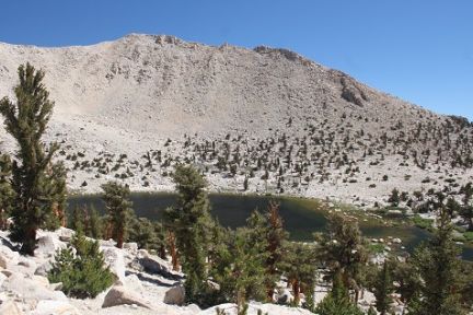 Chickenspring Lake
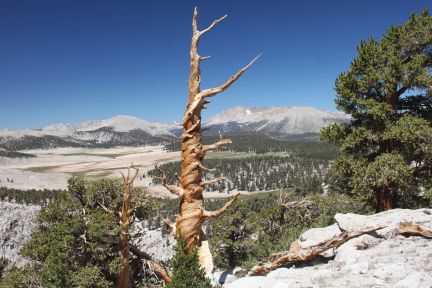 Overlooking Siberian outpost going from horseshoe meadow to Rock Creek"
 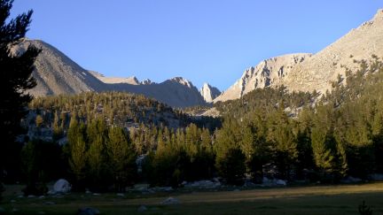 Crabtree Sunset
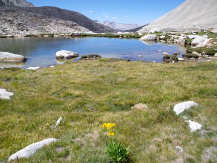 Guitar Lake
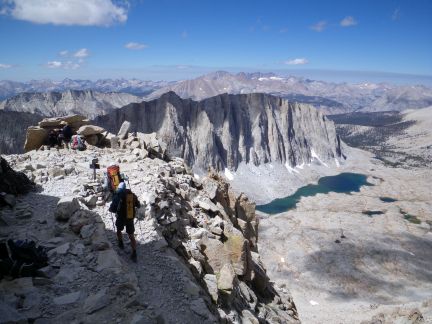
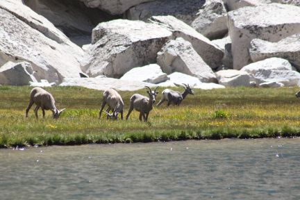 Chance for wildlife viewing at Soldier Lake...
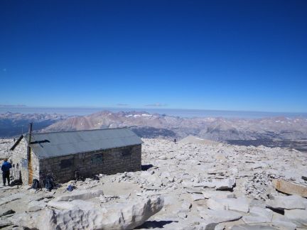
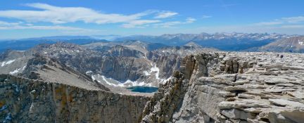
-campbell6x4.jpg) Looking Southwest from Mt. Whitney..
Looking Southwest from Mt. Whitney..