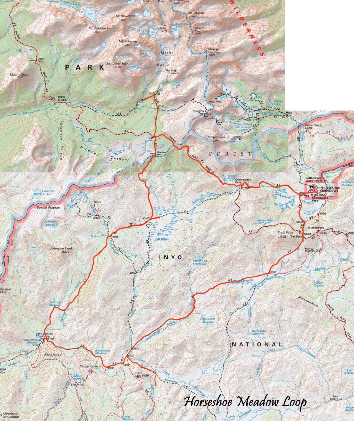
Trip Overview:
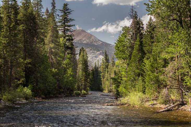
This trip gives the hiker an opportunity to see some stunning views and some historical artifacts! Watch for the rustic cabins of the historical Little Whitney Cow Camp, see granite peaks surrounding meadows of green and marvel at Mt. Langley. This is a beautiful hike with many options for day trips on layover days.
Hikers should be able to walk eight miles, 1,500 elevation gain and 2,500 loss. You should acclimate to 8,000 to 10,000 for 1-3 days prior to the trip. You should acclimate to at least 8,000 to 10,000 for 1-3 days prior to the trip.
Day 1: Horseshoe Meadow over Trail Pass to Tunnel Meadows
10 miles (est), 1,150 gain, 2,400 loss
The path drops 100 from the pack station to join the Cottonwood Pass trail. Follow the trail west a short distance to the Trail Pass junction at mile 0.3, turning left to cross Horseshoe Meadow toward Trail Pass. In one mile, the path will merge with a trail running along the east side of the meadow as it continues up 600 through forest to 10,500 Trail Pass and the junction with the Pacific Crest Trail. Enjoy views of the Golden Trout Wilderness before continuing straight, to drop 1,150 in 2.3 miles through open forest to the trail junction at Mulkey Meadow, a favorite lunch spot. There are two routes to camp from this point.
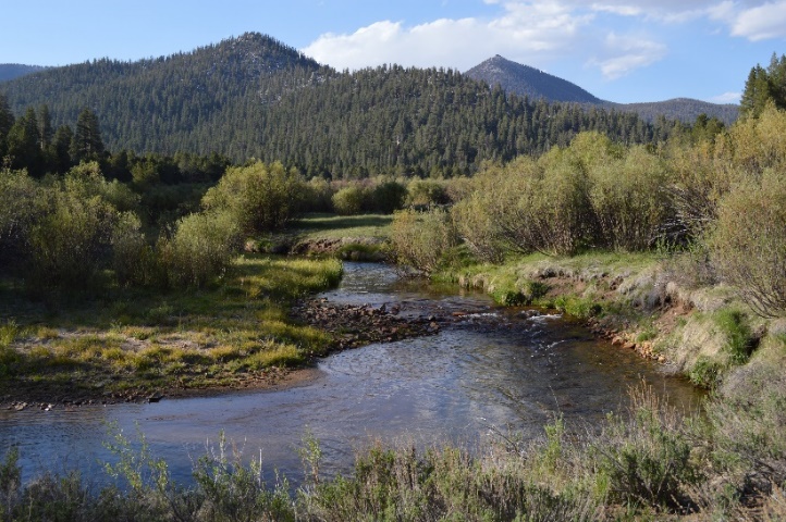
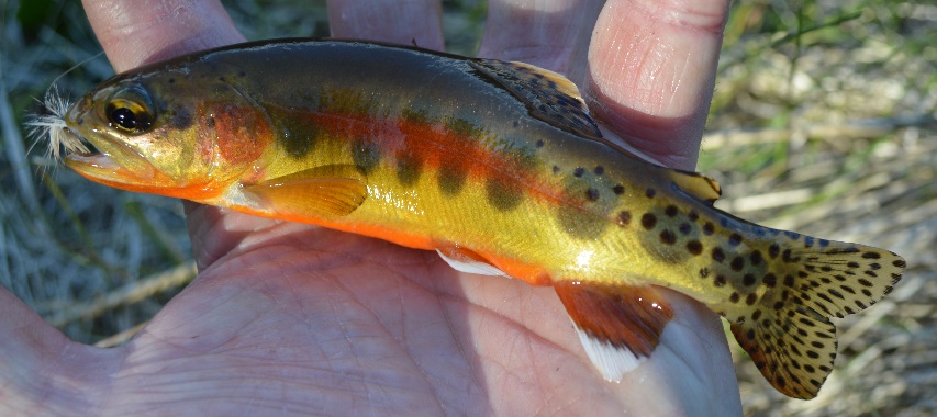
Turn right at the Mulkey Pass/Tunnel Meadow trail junction toward Tunnel Meadow. The trail skirts the northern edge of Bullfrog Meadow before climbing a low ridge and then descends along the South Fork of the Kern River, our first native golden trout creek. We make camp at the northern end of the meadow
Day 2:Tunnel Meadows to Little Whitney Meadows
Via Groundhog Meadow
8 miles, 200 gain, 650 loss.
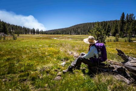
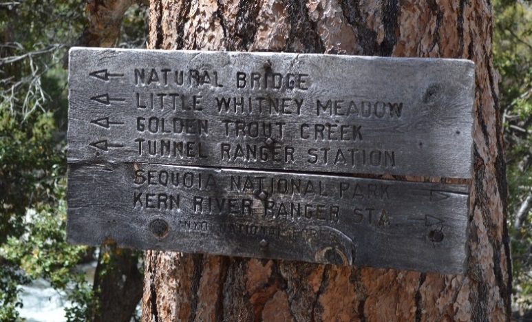
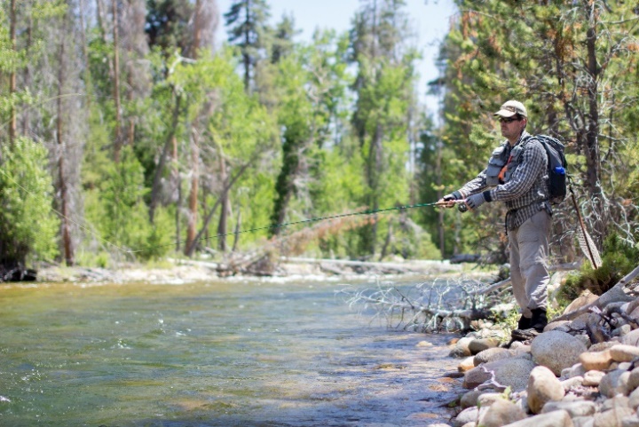
This short, relatively flat day offers anglers the opportunity to fish Golden Trout Creek. We travel alongside Tunnel Meadows. And, just after we leave the meadow we come to an unnatural dip in the trail. This a collapsed tunnel dug in the 1880s to divert water from Golden Trout Creek into the South Fork of the Kern River. Go straight toward Little Whitney Meadow at the Golden Trout Creek Trail . In another 0.6 miles, at the Volcano Meadow junction, turn right again, always following the trail signs to Little Whitney Meadow. The path follows Golden Trout Creek through Groundhog Meadow and past Cinder Cone and ancient lava flows before arriving at Little Whitney Meadow. Cross the meadow from the junction or navigate around the end of the meadow to our camp on the west side of the meadow. Watch for the rustic cabins of the historical Little Whitney Cow Camp at the north end of the meadow.
Day 3: LAYOVER at Little Whitney Meadows Camp
Day 4: Little Whitney Meadows to Big Whitney Meadows
8.6 miles, 2,250 gain, 950 loss.
Travel around the north side of Little Whitney Meadows to the trail that will follow Johnson Creek north, passing through Salt Lick Meadow before crossing to the east side of the creek. The trail climbs 1,900 in five miles to a saddle east of Johnson Peak before dropping 200 to the meadows of Barigan Stringer. Cross the creek to encounter two trail junctions. The first junction is the Rocky Basin Lakes Trail; go to the right. The second junction in just 0.1 miles is the Barigan Stringer Trail; go to the left toward Big Whitney Meadow to climb 200 over a low ridge before dropping 500 to the Siberian Pass junction at the edge of Big Whitney Meadow. Follow the trail east toward Cottonwood Pass 1/3 mile to our camp on the right side of the trail.
There is reliable water at the Johnson Creek and Barigan Stringer crossings.
Day 5: Big Whitney Meadows to Upper Rock Creek
6.3 miles, 1,400 gain, 700' loss.
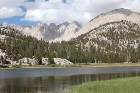
Return to the Siberian Pass junction and turn right to climb 1,150 in 3.2 miles to the pass. The trail crosses the desolate Siberian Outpost for 0.7 miles to the junction with the Pacific Crest Trail. Continue straight toward the New Army Pass junction, mile 5.3, and the Soldier Lakes junction, mile 5.8. The lower Soldier Lake is just up to the right of the Soldier Lake junction, but your path drops down 400 in ½ mile to camp at the eastern edge of the meadow surrounding Rock Creek Lake.
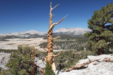
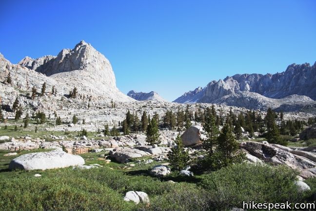
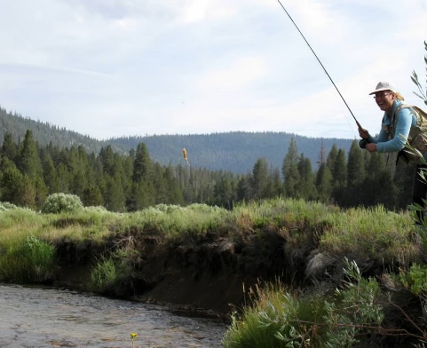
The camp at Upper Rock Creek is a comfortable location with excellent layover options. One can spend a relaxing day following the creek as it winds through meadows and cascades over slick rock or follow the trail back up to Soldier Lake. Miter Basin offers stunning views of meadows surrounded by granite peaks. Mt. Langley will call to the more adventurous hikers. See the Layover Day Trips in the next section for detailed descriptions.
There is little reliable water along the route.
Day 6: Layover Day ( at Upper Rock Creek Camp) --- Explore the Miter Basin or climb Mt. Langley
Option to explore Miter Basin:
6.0 miles, 1,100 gain and loss
There is an unmaintained trail that follows Rock Creek into Miter Basin from near the small lake. The trail climbs through open forest to a large meadow and then continues up the basin to a mix of slick rock and meadow where you are surrounded by 13,000-14,000 peaks, about two miles and 700 elevation gain. You can follow the drainage up an additional mile and 400 elevation gain to beautiful Sky Blue Lake. Other lake basins and Crabtree Pass (12+ miles round trip, 2,400 gain and loss) are additional options. Your distance depends on how far you elect to venture into the basin.
Option to Summit Mt. Langley
11+ miles, 3,700 gain and loss
To hike to the top of Mt. Langley, return up the trail past the Soldier Lake junction and then turn left at the junction to New Army Pass. Follow the trail up to (Old) Army Pass and then turn north and ascend the scree and gravel on the south slopes of Mount Langley. The slope gets steeper towards the end. The easiest route is found by skirting the summit plateau slightly to the left to avoid the steep rock straight ahead. Once the plateau is reached, hike straight North, and when you reach the steep North Face of Langley, turn right and head West toward the summit. The summit is an unimpressive platform of sand and rocks, but the views in all directions are amazing. Source: http://www.summitpost.org/army-pass-normal-route/156296
Day 7: Upper Rock Creek over Cottonwood Pass to Horseshoe Meadow
10.8 miles, 1,600 gain, 1,935 loss
Follow the trail up to the Soldier Lake junction, 400 in ½ mile. Turn right and follow the path past the junction of New Army Pass, mile 1.0, to the Pacific Crest Trail at mile 2.1. Go left at the junction toward Cottonwood Pass to travel through open forest past Chicken Spring Lake to the pass, mile 6.7. Leave the Pacific Crest Trail toward Horseshoe Meadow, dropping 1,300 in 4.1 miles to the pack station.
The only reliable water is at Chicken Spring Lake.
While the packers will follow the Cottonwood Pass route, an alternate route for hikers is over New Army Pass, 12.5 miles with a 1,750 gain and 2,100 loss.
Please note that this represents the planned itinerary. Weather or other factors may affect the choice of campsites and daily travel. All decisions are made by the Head Packer with attention to the safety and comfort of guests and stock.
*Mileage, gain, and loss based on Guthooks PCT Guide.
What you need to know
for hikers on pack stock supported trips
Dunnage limit is 30 lbs. per person (this includes sleeping bags, fishing equipment, liquor, etc.)
You may bring your own tent up to 10 pounds that is in addition. The PCT 28 day trip allows 35 pounds of duffel.
PERSONAL CHECK LIST
Bring belongings in stout canvas or nylon duffels; side zipper recommended, ideal size approximately 14" x 32". It is a good idea to use a large plastic bag INSIDE of the duffle to protect contents from external moisture.
Sleeping bags can be in separate duffels --again, line the inside of the duffle against rain.
Place all cosmetics, soaps, medications, etc into small plastic containers with close-fitting caps, THEN into sturdy resealable plastic storage bags. If anything breaks or bursts from altitude changes, the plastic bag contains the spill.
When possible, it is a good idea to transfer alcoholic beverages to sturdy plastic bottles with well fitting caps - it will save weight and protect against breakage.
ESSENTIALS
- Footwear. For this trips a medium-weight pair of hiking boots. We
do not recommend lightweight hikers or tennies since they give
little ankle support and the soles are often thin.
- Camp Shoes. A lightweight pair of tennies or Tevas to wear in
camp. This will reduce vegetation damage at our campsites.
- A day pack. It should be large enough to take water, extra clothing, rainwear,
camera, etc during the days.
- Sleeping Bag. Most summer trips are warm and a bag rated to
about 25°F will be plenty warm enough. We much prefer down
bags, and good quality ones at that. Your bag should weigh in
around 3 pounds.
- Sleeping pad. A 3/4 or full length closed cell foam or Thermarest.
If you bring a Thermarest also bring a repair kit to fix pesky holes!
- Coffee mug (plastic for camp)
CLOTHING
- 2 pair synthetic liner socks.
- 2 pair heavier synthetic or wool blend socks.
- Long underwear top. Capilene, some other synthetic or the new
pure Merino wool types.
- Long underwear bottom.
- Warm pants. Tights or Expedition Weight Capilene.
- Warm shirt. Synchilla or R2 weight works well.
- Another fuzzy sweater top or pile jacket of some sort
- GoreTex Jacket and Pants. A lightweight set is sufficient and heavy
bulky clothing is unnecessary. Side zips on the pants should be
long enough to slide over boots. Jacket must have a hood. Do not
skimp on your rain gear. Nylon ponchos are not acceptable.
- Shorts for on the trail
- Tee shirt for on the trail
- Lightweight capilene or similar gloves.
- Warm hat. Synthetic or wool.
- Sunhat
ETC.
- Sun glasses.
- Water Bottles. Two quart (1 liter) wide mouth bottles and/or a hydration
system holding up to 50oz. (2 liters). Dont bring bike bottles or
any bottle that doesnt have a wide opening.
- Headlamp. --and a spare set of batteries!
- Pocket knife. Swiss army style.
- Personal toiletries. It is not necessary to smell like a rose each day
so do not over do it.
- Ear plugs are great to have in a noisy tent.
- Personal Medical Kit. The guide will carry a large kit so yours will
predominately consist of foot repair items, mild pain killer such as
Advil and bandaids.
- Sunscreen and lip screen. SPF 30+. A 1oz. bottle will be enough.
Make sure the lip stuff actually contains a sunscreen.
- Bug repellent.
- Camera. A spare battery and card are good backups
- Ski/trekking poles. These are not essential, but can be handy on
the trail. It is your choice, but they do save wear on the knees.
- Plastic trash bag. Handy for keeping gear in outside the tent
should it rain.
- Optional reading material, etc.
FOOD
We provide the all meals on scheduled trips. You can bring
your favorite "on-the-trail" snacks.
OPTIONAL ITEMS
- Small notepad and pencil
- Collapsible plastic wash basin (optional)
- Solar shower (optional)
- Water filtering pump (optional)
- Liquor (be sure to check in with the packers to see that your liquor is packed safely)
- Fishing equipment (optional)
- Rod/reel/line (a rod that breaks down into 3 or more pieces is recommended)
- Compact metal rod case to carry on saddle
- Canvas creel (no tackle boxes)
- Leader material (1-3 lb.)
- Flies: black gnat, mosquito, grey hackle, brown hackle, & royal coachman (No. 12-14 hooks)
- Bait: worms & Pautzke red eggs
- Egg hooks, worm hooks (No. 10-14)
- Split shot
- Lures (personal choice)
- Pliers
For Riders:
What you need to know
for riders
(TRAIL RIDE, ALL EXPENSE, AND BASE CAMP INFORMATION)
OUR SERVICES
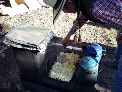
We supply horses, saddles, food, kitchen and eating utensils, and camping equipment. Dormitory tents will be provided for men and women. Private tents for couples or singles will be reserved by request. Food will be plentiful and deluxe in quality. We provide the preparation of meals; any help is appreciated but not mandatory. Those desiring to learn how to pack may participate in making up loads and packing the mules.
IMPORTANT INFORMATION
- Check-in time is 7 a.m. at Rock Creek Pack Station except when OTHER LOCATION is specified.
- Free parking for guests' cars at pack station.
-
Breakfast is served the first day while the mules are being loaded.
The last meal furnished is lunch the last day.
- We provide a small saddle bag for trail necessities. Please do not bring your own saddle bags or day packs unless they
are pocket size. Participants may not carry large camera
cases with extra lenses on the saddle. If you have extra camera equipment, it can be packed in your duffel or in a
safe place on mules.
-
You will be limited to 3 lbs. in the saddle bag, which includes your lunch.
Your jacket and rain gear are not included in the 3 lbs. and may be tied on the back of the saddle. No day packs allowed on riders' backs.
- Each person is assigned a horse for the duration of the trip with regard to the guest's weight, height, and ability.
- Dunnage limit is 30 lbs. per person (this includes sleeping bags, fishing equipment, liquor, etc.).
There will be a surcharge of $3 to $10 per pound on dunnage in excess of the 30 lbs. You may bring your own tent if under 10 lbs. which will not be included in 30 lb. weight limit.
- Trip fee does not include alcoholic beverages or lodging night before and after trip.
- Gratuities are optional and a personal choice.
- Trip will terminate in the late afternoon of last day.
- Free shuttle back to Rock Creek Pack Station for trips terminating at other road heads.
- Reservation form must be accurately completed.
The information on age, height, weight and riding ability is used to assign riding animals. Failure to provide accurate information may result in the participant being denied going on the trip with loss of trip fee.
- We advise guests to purchase cancellation and trip travel insurance.
- Participants will be sent an assumption of risk and a liability release form. All guests must assume the risk and sign the forms before using Rock Creek's service. Our forms have excellent guidelines for riding safety that we ask you to study.
- The pack station does not boil or treat water. Campsites are remote enough that we feel safe in using the water. It you want to purify water bring your own filter pump or purification tablets.
PERSONAL CHECK LIST
Bring belongings in stout canvas or nylon duffels; side zipper recommended, ideal size approximately 14" x 32".
It is a good idea to use a large plastic bag INSIDE of the duffle to protect contents from external moisture.
Sleeping bags can be in separate duffels --again, line the inside of the duffle against rain.
Place all cosmetics, soaps, medications, etc into small plastic containers with close-fitting caps,
THEN into sturdy resealable plastic storage bags.
If anything breaks or bursts from altitude changes, the plastic bag contains the spill.
When possible, it is a good idea to transfer alcoholic beverages to sturdy plastic bottles with well fitting caps - it will save weight and protect against breakage.
Check in fishing worms and bottle goods separately; don't put in duffel. Place fishing rods in metal or plastic cases.
You will be given a small saddle bag that goes on your saddle horn to carry your lunch and a few personal items. (Weight limit 3 lbs - including lunch).
Remember - try to minimize the weight of your dunnage by packaging only
the amount of any item you will need (like soaps, lotions and medications).
RECOMMENDED ITEMS:
- Sleeping bag with a comfort range of 20 to 60 degrees and a moisture proof ground cloth.
- Air mattress or small 1/4"-1/2" foam hip pad recommended - your night's rest will affect your next days enjoyment.
Bring the best sleeping pad you can manage.
- Broad-brimmed hat is essential for protection from sun at high altitude. It must have strings to keep from blowing off.
- Sunglasses (RX glasses) - high altitude sun is BRIGHT!
- Coffee mug (plastic for camp)
- Pint water bottle for your horn bag
- Pocket knife or small multi-tool
- Flashlight and extra batteries
- Camera and film (sturdy strap)-- if using digital - don't forget an extra battery and card
- Rain jackets and pants or slicker (rolled up you can tie them to the back of your saddle)
- Hat protector (to keep your hat dry)
- Light jacket (windbreaker)
- Wool or fleece pullover/sweater (layers will keep you comfortable)
- Heavy jacket
- Bandana
- Woolen cap (evenings can be cold)
- Gloves (recommend gloves for riding, may want warm gloves for evenings)
- Socks
- Riding boots
- Shoes for camp (moccasins, athletic shoes, etc)
- Shirts and pants (long sleeved shirts offer sun, bug and branch protection)
- Underwear
- Bathing suit
- Bath towel/wash cloth/soap (try a multi-use bar or liquid for use on hair, body and laundry. Biodegradable choices are available.)
- Insect repellent such as Cutters
- Toothbrush/toothpaste
- comb/brush clips/pins/ponytail holders
- Shaving kit (a small mirror is helpful)
- Sun Screen (lotion, cream or stick)- use liberally for sunburn and chapping prevention.
- Chapstick with sun protection SPF 15 or better
- Moisturizer (cream or lotion - altitude and sun can be dry and chap skin)
- Prescription medicine (if required - if you have any allergies, remember to bring appropriate medication)
- Band-aids, aspirin, ibuprofen, eye drops, moleskin for any blisters
- Baby powder/Talcum powder (helps to relieve any raw or irritated areas from boots, clothes or saddles)
- Kleenex
- Jogging suit (sweats are comfortable for after-swim and campfire lounging)
OPTIONAL ITEMS:
- Small notepad and pencil
- Collapsible plastic wash basin (optional)
- Solar shower (optional)
- Water filtering pump (optional)
- Liquor (be sure to check in with the packers to see that your liquor is packed safely)
- Fishing equipment (optional)
- CALIFORNIA FISHING LICENSE. Please note that fishing licenses are NOT available at or near the pack station. Be sure to get one BEFORE you arrive for your adventure. You can find information on California fishing licenses and online purchase at TakeMeFishing.org. You can purchase them at a Bishop sporting goods store, as well.
- Rod/reel/line (a rod that breaks down into 3 or more pieces is recommended)
- Compact metal rod case to carry on saddle
- Canvas creel (no tackle boxes)
- Leader material (1-3 lb.)
- Flies: black gnat, mosquito, grey hackle, brown hackle, & royal coachman (No. 12-14 hooks)
- Bait: worms & Pautzke red eggs
- Egg hooks, worm hooks (No. 10-14)
- Split shot
- Lures (personal choice)
- Pliers
LOW-IMPACT GUIDE FOR THE WILDERNESS USER
We are dedicated to conducting our trips so that others following us will find the country unspoiled. Livestock is a natural part of the wilderness and when properly managed enhances man's enjoyment of our unmechanized wilderness area. Today, just as it was when the entire west was mostly wilderness, the horse and mule remain our companions and servants in wilderness travel. We practice and expect you to observe the following during your trip.
- Keep horses on trail; do not cut switchbacks (corners).
- Tie horses 200 feet away from streams, trails and campsites. At camps, horses and mules are tied to picket lines,
stretched between trees on granitic soil.
- If you can't tie animal to picket line use a tree greater than 8" in diameter, not on grass. Tie high and short (2-3 ft.) so horse doesn't get foot caught in rope.
- Choose a tent site at least 100 ft. from water (THE LAW) where drainage will not be a problem, avoiding the need to trench. No tents or camp area allowed on grass or meadowlands.
- Utilize pre-existing fire rings where possible. Don't surround fires with rocks! Dig a hole in sand and cover when finished. When you leave camp, bury ashes from fire rings. Leave existing fire rings clean for the next user.
- When breaking camp, return the spot to its natural state and broadcast a covering of needles and cones. Scout the area to make sure nothing will be left behind. Remove the smallest pieces of aluminum foil and trash.
- Pack out all trash. Don't bury garbage, scatter organic wastes or leave foil in campfire pit. Burn cans and flatten. On our group trips we have a bag for cans and aluminum foil.
- Don't use soap (even biodegradable) in streams or lakes, Wash yourself, clothes and dishes away from water sources.
- Bury human waste 200 ft. from water, campsites and trails. Dig a hole 4-6" deep and after use tamp with sod.
- Don't pick flowers or cut branches from live trees. Use only downed wood for fires.
- You are required to keep bears from getting to your food at all times. Please ask for current regulations and suggestions on how to prepare for your trip.
info_for_hikers_include.shtml
info_for_riders_include.shtml
MAPS
TOM HARRISON MAPS.
Tom Harrison Maps, paper or download onto phone/tablet:
- Golden Trout Wilderness
- Mt. Whitney High Country
Apps for Smartphone/Tablet, download applicable areas prior to departure: