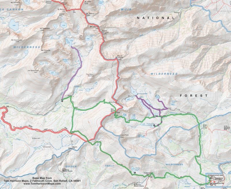
Trip Overview:
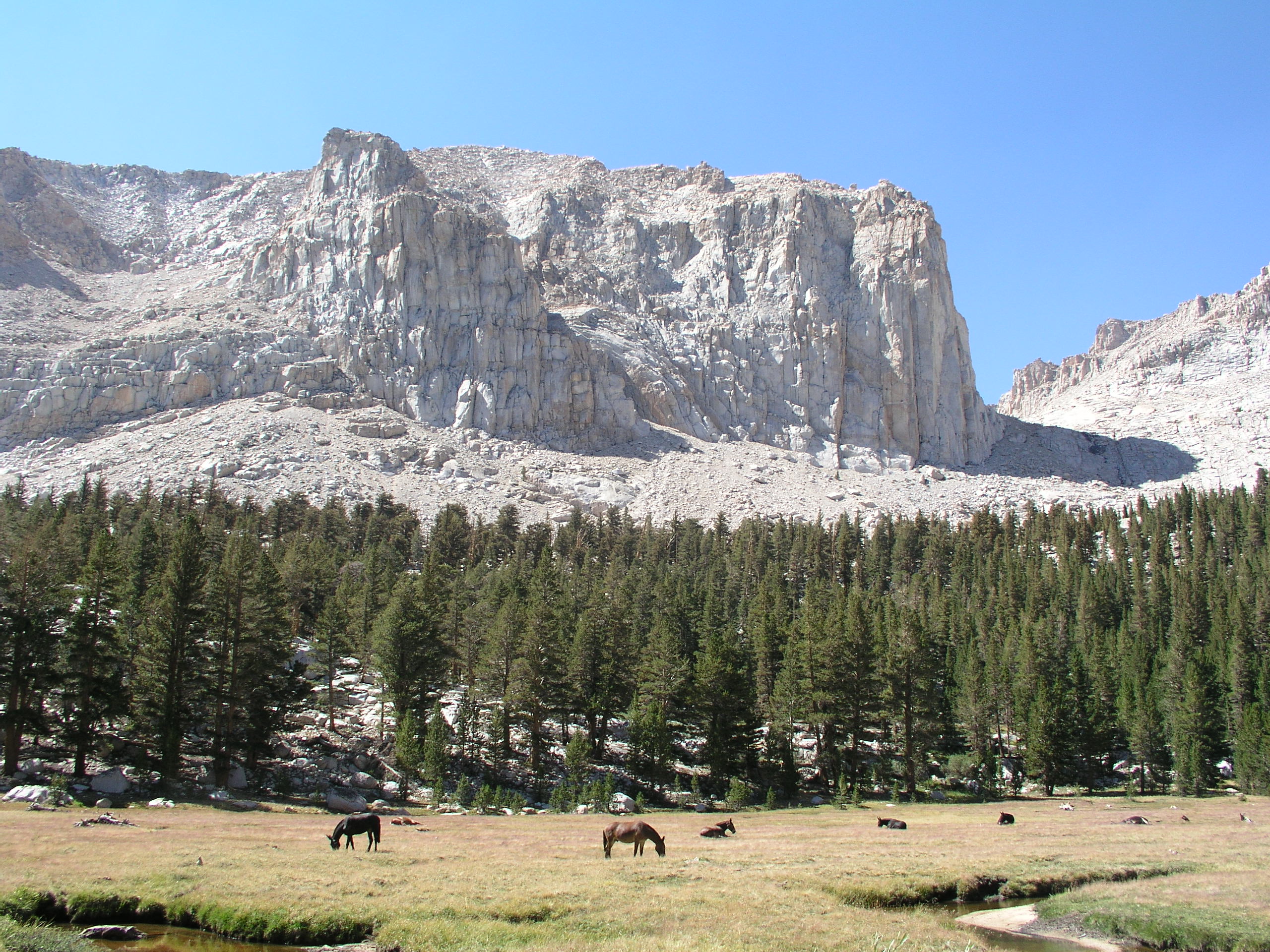
There are many beautiful lake basins in the Sierra, but the surrounding peaks, lakes, and meadows of Miter Basin make it one of the best. The close proximity to Mt. Whitney draws backcountry travelers in the quest to bag the highest peak in the lower 48 which leaves this scenic basin remarkably empty. This trip will take you along a section of the Pacific Crest Trail to stage you for a hike into Miter Basin on a layover. You will return over New Army Pass into the beautiful Cottonwood Lakes Basin with another layover day to explore the many lakes in this cirque encircled basin.
Arrive at the Cottonwood Pack Station by 7:00 AM where you will be served breakfast, your gear will be weighed, and your cook will hand you a sack lunch to carry on your hike. Your personal vehicles may be left in the pack station parking.
Begin and End at Cottonwood Pack Station
Hikers should be able to walk eight miles, 2,000' elevation gain and loss. You should acclimate to 8,000 to 10,000 for 1-3 days prior to the trip. You should acclimate to at least 8,000 to 10,000 for 1-3 days prior to the trip.
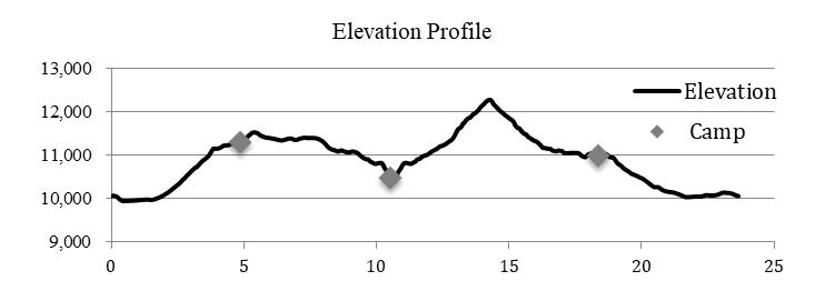
Distance: 24.4 miles, 4,320 total gain and loss on moving days.
Elevation Profile:
Please note: While the route passes quite a few lakes and streams during the hike, the sections between the camps can be dry. You should carry ample water for the day as you leave camp each morning.
Day 1: Cottonwood Pack Station to Chicken Spring Lake
4.7 miles, 1,400 gain, 250 loss
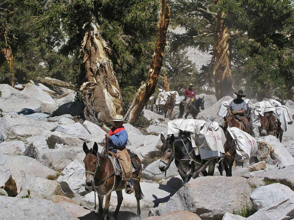
The day will start with a 7:00 breakfast at Cottonwood Pack Station. The walk begins by descending 0.3 miles to the trail and then ascends gently beside the meadow for a mile before entering open forest to climb steadily for almost 1,000 to 11,160 Cottonwood Pass by mile 4.1. We will turn north onto the Pacific Crest Trail, walking easily for another half mile before leaving the trail to follow the creek a short distance up to Chicken Spring Lake.
Day 2: Chicken Spring Lake to Upper Rock Creek
6.1 miles, 590 gain, 1,350 loss
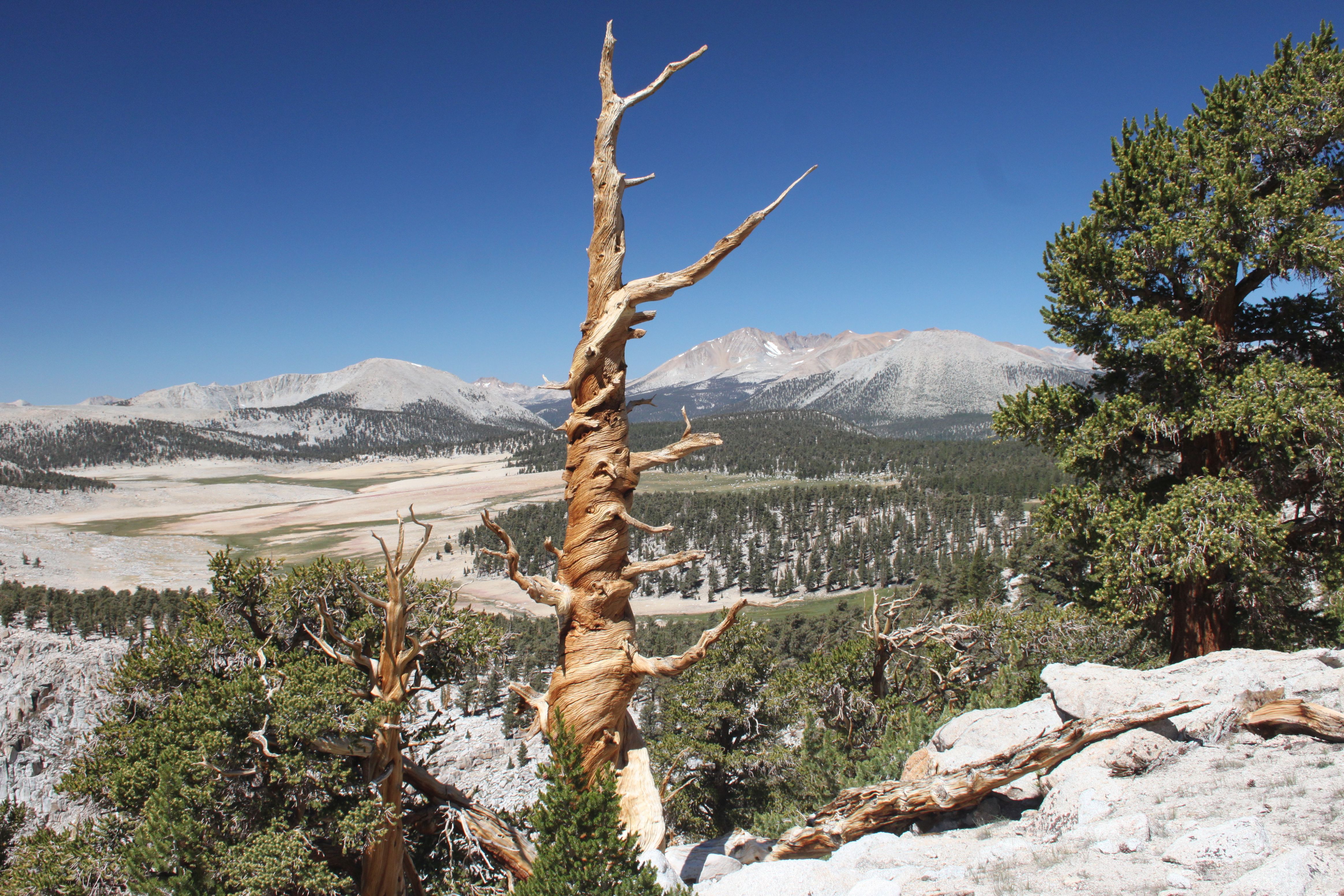
The trail climbs a 250 ridge before traversing the shoulder of Cirque Peak in open forest with good views of Big Whitney Meadows to the south. The route passes the Sequoia Park Boundary in three miles and soon comes to the Siberian Pass/Rock Creek Trail Junction. Turn right toward Rock Creek to descend easily for 1.1 miles through open forest to a creek crossing and the New Army Pass Trail junction. Continue straight to the Soldier Lake junction in 0.6 miles. Follow the trail left to drop more steeply for 0.6 miles along the tumbling outlet creek to the large meadow of Upper Rock Creek.
The Upper Rock Creek camp is the perfect base for a day hike into Miter Basin or a pleasant ramble down Rock Creek. See the Day Hikes and Side Trips section.
Day 3: LAYOVER at Upper Rock Creek
Explore Miter Basin.
Day 4: Upper Rock Creek to Cottonwood Lakes and South Fork Lakes
8.3 miles, 2,060 gain, 1,510 loss
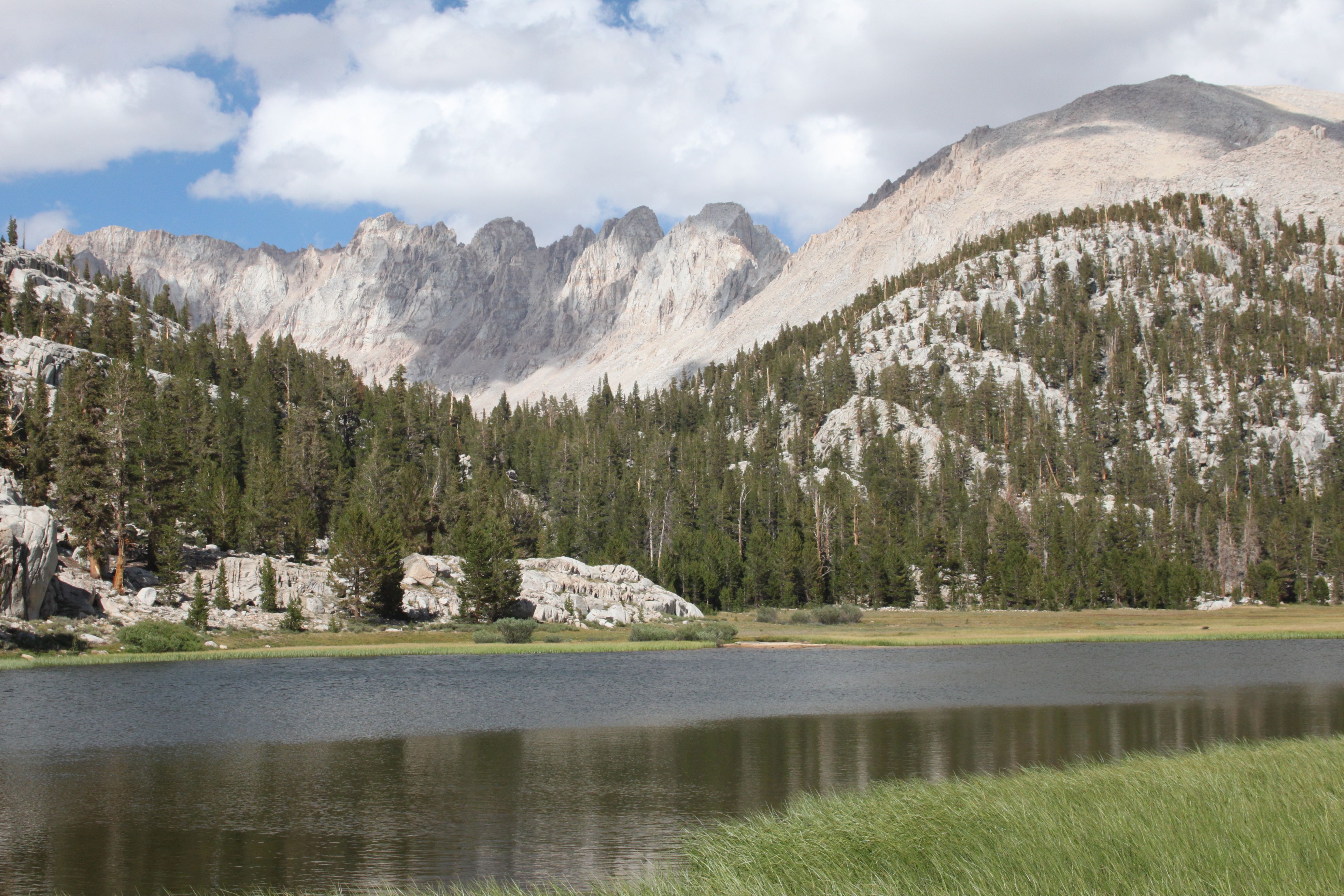
Return 0.6 miles to the Soldier Lake Junction, turning right and then turning left in 0.6 miles toward New Army Pass. The trail soon climbs out of the trees, ascending more aggressively up the barren cirque. The route comes to the unsigned (Old) Army Pass in 0.9 miles, 900 of gain. Continue to the right to climb another 500 in 1.6 miles to New Army Pass. Enjoy the views to the west down the Rock Creek drainage before turning your attention to the panoramas of Cottonwood Basin. The trail now drops down the cirque wall 840 in 1.4 miles on rocky switchbacks past the south shore of High Lake. The descent moderates as it passes through a picturesque grassy, wildflower-dotted area above Long Lake. The path skirts the south shore of the lake before entering open forest, passing the western end of the string of South Fork Lakes before swinging northeast. The route briefly crosses a boulder field before passing Cottonwood Lake #2 and the meadowed Cottonwood Lake #1 on a fairly level trail. The trail now descends a forested moraine on switchbacks for 0.2 miles to the Cirque Lake Trail junction. Follow the Cirque Lake Trail to the right for ½ mile to the eastern end of the string of South Fork Lakes.
Day 5: LAYOVER day
Day 6: South Fork Lakes to Cottonwood Pack Station
5.3 miles, 270 gain, 1,210 loss
Returning the ½ mile to the New Army Pass Trail, the route turns right to descend moderately and continues straight past the Cottonwood Lakes Trail junction in 1.3 miles. The gently descending trail passes a meadow and then parallels Cottonwood Creek through forest. The route crosses the South Fork Creek at mile 3.8 to easily descend to the Cottonwood Lakes Trailhead junction in another 1.2 miles. Turn right at this junction to walk another 1/3 mile to Cottonwood Pack Station.
DAY HIKES AND SIDE TRIPS
Sky Blue Lake/Miter Basin
5.4 miles round trip, 1,150 gain and loss
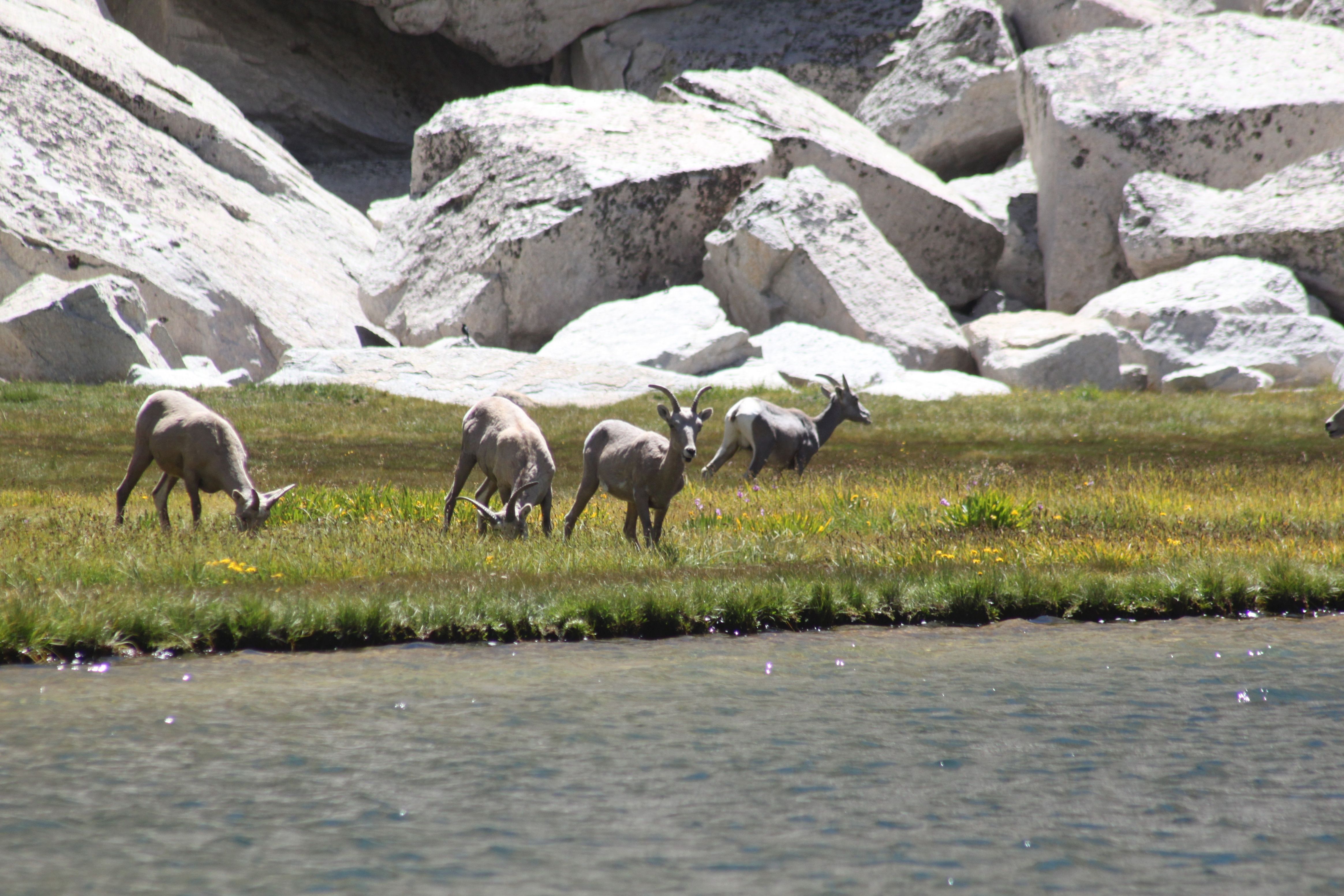
There is an unmaintained trail that follows Rock Creek into Miter Basin starting about 250 west of where the trail from Soldier Lake arrives at the meadow. The trail climbs through open forest to a large meadow and then continues up the basin to a mix of slick rock and meadow, about two miles and 700 elevation gain, where you are surrounded by 13,000-14,000 peaks. You can follow the drainage up an additional mile and 400 elevation gain to beautiful Sky Blue Lake. Other lake basins and Crabtree Pass (12+ miles round trip, 2,400 gain and loss) are options. Your distance depends on how far you elect to venture into the basin.
Water is readily available in Miter Basin in normal rain years.
Upper Rock Creek
5.4 miles round trip, 650 loss and gain
Take a pleasant ramble past Upper Rock Creek Lake and down Rock Creek as it changes moods between slowly winding through meadows and cascading over rocky drops. The distance shown is to the junction with the Pacific Crest Trail.
Mt. Langley Side Trip
5.2 additional miles round trip, 2,150 additional gain and loss
Peak baggers may want to summit Mt. Langley as a side trip between Upper Rock Creek and the Cottonwood Lakes. As you ascend the New Army Pass Trail, watch for an unmaintained trail to (Old) Army Pass on the left at elevation, about 1.9 miles and 950 up the trail. Turn north and ascend the scree and gravel on the south slopes of Mount Langley. The slope gets steeper towards the end. The easiest route is found by skirting the summit plateau slightly to the left to avoid the steep rock straight ahead. Once the plateau is reached, travel straight north, and when you reach the steep North Face of Langley, turn right and head west toward the summit. The summit is an unimpressive platform of sand and rocks, but the views in all directions are amazing. Source: summitpost.org.
Water is available to Soldier Lake and may be available part way up the New Army Pass Trail.
Cottonwood Lakes Basin (from South Fork Lakes)
4.6-6.4 miles, 250-380 gain and loss
Looking down on the Cottonwood Lakes as you descend from New Army Pass is one thing. Walking among them is yet another. A layover day on the South Fork Lakes affords the opportunity to visit the upper Cottonwood Lakes. Return ½ mile to the New Army Pass Trail and turn left toward the pass to climb up the moraine for 0.2 miles. Ignore the Cottonwood Lakes Cutoff Trail #1 and turn right in another 0.3 miles onto the Cottonwood Lakes Cutoff Trail #2 (3513B) that will take you north between Lake #1 and Lake #2. Ascend easily for 1.0 mile along Lake #3 to the junction with the Cottonwood Lakes Trail (3516). Continue straight 1/3 mile to Lakes #4 and #5 that are nestled beneath a 1,200 cirque headwall for perhaps the perfect lunch spot. Return 1/3 mile to turn left onto Cottonwood Lake Trail. Continue for 1.0 miles to the Cottonwood Lakes Cutoff #1 Trail (3513A).
From there, you could:
-
Return to camp by turning right onto the Cottonwood Lakes Cutoff Trail #1 (3513A), then left on the New Army Pass Trail in 0.3 miles to drop 0.2 miles down the moraine on switchbacks and then turn right at the Cirque Lake Trail Junction to our camp, ½ mile from the junction.
-
Explore farther by continuing on the Cottonwood Lakes Trail for 0.3 miles and then turning left onto the Muir Lake Trail (3516C). Follow the trail an additional 0.6 miles and 130 gain to the lake. After enjoying the lake, return to the Cottonwood Lakes Cutoff Trail #1, turning left, then left on the New Army Pass Trail in 0.3 miles to drop 0.2 miles down the moraine on switchbacks. Turn right at the Cirque Lake Trail junction to our camp, ½ mile from the junction.
Distances and Elevations
| Location | Cumulative
Distance | Daily
Distance | Elevation |
| Cottonwood Pack Station | 0.0 | | 10,080
|
| Cottonwood Pass/Trail Pass Trails Jct | 0.3 | | 9,950
|
| Enter Trees and Switchbacks | 2.5 | | 10,210
|
| PCT Junction | 4.1 | | 11,160
|
| Chicken Spring Lake Use Trail | 4.7 | 4.7 | 11,230
|
| Sequoia NP | 7.8 | | 11,370
|
| Siberian Pass Jct | 8.7 | | 11,060
|
| New Army Pass Trail Jct | 9.8 | | 10,940
|
| Soldier Lake Trail Jct | 10.4 | | 10,720
|
| Miter Basin Trail Jct | 10.8 | 6.1 | 10,470
|
| Soldier Lake Trail Jct | 11.2 | | 10,720
|
| New Army Pass Trail Jct | 11.8 | | 10,940
|
| Army Pass Trail Jct | 12.7 | | 11,860
|
| New Army Pass | 14.3 | | 12,310
|
| Near First South Fork Lake | 15.8 | | 11,110
|
| Cottonwood Lakes Jct #1 | 18.1 | | 11,040
|
| Cottonwood Lakes Jct #2 | 18.4 | | 11,060
|
| Cirque Lake Jct | 18.6 | | 10,980
|
| South Fork Lakes Camp | 19.1 | 8.3 | 11,020
|
| Cirque Lake Jct | 19.6 | | 10,980
|
| Cottonwood Lakes Jct #3 | 20.9 | | 10,475
|
| South Fork Trail Jct | 22.9 | | 10,040
|
| Cottonwood Lakes Trailhead Jct | 24.1 | | 10,120
|
| Cottonwood Pack Station | 24.4 | 5.3 | 10,080
|
Note: Mileage is based on Tom Harrison maps. Distances between junctions and gain/loss data are estimated based on Gaia GPS and Natural Atlas. Campsite latitude and longitude information is based on Yosemite National Park Stock Camp locations.
This represents the planned itinerary. Weather or other factors may affect the choice of campsites and daily travel. All decisions are made by the Head Packer with attention to the safety and comfort of guests and stock.
What you need to know
for hikers on pack stock supported trips
Dunnage limit is 30 lbs. per person (this includes sleeping bags, fishing equipment, liquor, etc.)
You may bring your own tent up to 10 pounds that is in addition. The PCT 28 day trip allows 35 pounds of duffel.
PERSONAL CHECK LIST
Bring belongings in stout canvas or nylon duffels; side zipper recommended, ideal size approximately 14" x 32". It is a good idea to use a large plastic bag INSIDE of the duffle to protect contents from external moisture.
Sleeping bags can be in separate duffels --again, line the inside of the duffle against rain.
Place all cosmetics, soaps, medications, etc into small plastic containers with close-fitting caps, THEN into sturdy resealable plastic storage bags. If anything breaks or bursts from altitude changes, the plastic bag contains the spill.
When possible, it is a good idea to transfer alcoholic beverages to sturdy plastic bottles with well fitting caps - it will save weight and protect against breakage.
ESSENTIALS
- Footwear. For this trips a medium-weight pair of hiking boots. We
do not recommend lightweight hikers or tennies since they give
little ankle support and the soles are often thin.
- Camp Shoes. A lightweight pair of tennies or Tevas to wear in
camp. This will reduce vegetation damage at our campsites.
- A day pack. It should be large enough to take water, extra clothing, rainwear,
camera, etc during the days.
- Sleeping Bag. Most summer trips are warm and a bag rated to
about 25°F will be plenty warm enough. We much prefer down
bags, and good quality ones at that. Your bag should weigh in
around 3 pounds.
- Sleeping pad. A 3/4 or full length closed cell foam or Thermarest.
If you bring a Thermarest also bring a repair kit to fix pesky holes!
- Coffee mug (plastic for camp)
CLOTHING
- 2 pair synthetic liner socks.
- 2 pair heavier synthetic or wool blend socks.
- Long underwear top. Capilene, some other synthetic or the new
pure Merino wool types.
- Long underwear bottom.
- Warm pants. Tights or Expedition Weight Capilene.
- Warm shirt. Synchilla or R2 weight works well.
- Another fuzzy sweater top or pile jacket of some sort
- GoreTex Jacket and Pants. A lightweight set is sufficient and heavy
bulky clothing is unnecessary. Side zips on the pants should be
long enough to slide over boots. Jacket must have a hood. Do not
skimp on your rain gear. Nylon ponchos are not acceptable.
- Shorts for on the trail
- Tee shirt for on the trail
- Lightweight capilene or similar gloves.
- Warm hat. Synthetic or wool.
- Sunhat
ETC.
- Sun glasses.
- Water Bottles. Two quart (1 liter) wide mouth bottles and/or a hydration
system holding up to 50oz. (2 liters). Dont bring bike bottles or
any bottle that doesnt have a wide opening.
- Headlamp. --and a spare set of batteries!
- Pocket knife. Swiss army style.
- Personal toiletries. It is not necessary to smell like a rose each day
so do not over do it.
- Ear plugs are great to have in a noisy tent.
- Personal Medical Kit. The guide will carry a large kit so yours will
predominately consist of foot repair items, mild pain killer such as
Advil and bandaids.
- Sunscreen and lip screen. SPF 30+. A 1oz. bottle will be enough.
Make sure the lip stuff actually contains a sunscreen.
- Bug repellent.
- Camera. A spare battery and card are good backups
- Ski/trekking poles. These are not essential, but can be handy on
the trail. It is your choice, but they do save wear on the knees.
- Plastic trash bag. Handy for keeping gear in outside the tent
should it rain.
- Optional reading material, etc.
FOOD
We provide the all meals on scheduled trips. You can bring
your favorite "on-the-trail" snacks.
OPTIONAL ITEMS
- Small notepad and pencil
- Collapsible plastic wash basin (optional)
- Solar shower (optional)
- Water filtering pump (optional)
- Liquor (be sure to check in with the packers to see that your liquor is packed safely)
- Fishing equipment (optional)
- Rod/reel/line (a rod that breaks down into 3 or more pieces is recommended)
- Compact metal rod case to carry on saddle
- Canvas creel (no tackle boxes)
- Leader material (1-3 lb.)
- Flies: black gnat, mosquito, grey hackle, brown hackle, & royal coachman (No. 12-14 hooks)
- Bait: worms & Pautzke red eggs
- Egg hooks, worm hooks (No. 10-14)
- Split shot
- Lures (personal choice)
- Pliers