Trip Overview:
Arrive at Virginia Lakes Pack Outfit by 7:00 AM where your gear will be weighed and you will be served breakfast. Your personal vehicles will be left in the pack station parking area.
Begin at Virginia Lakes; Ending at Tuolumne Meadows.
You will be ferried the one mile from the pack station to the trailhead. A pack station driver will pick you up at the Tuolumne Meadows Stable parking area located west of Lembert Dome, returning you to the Virginia Lakes Pack Outfit station.
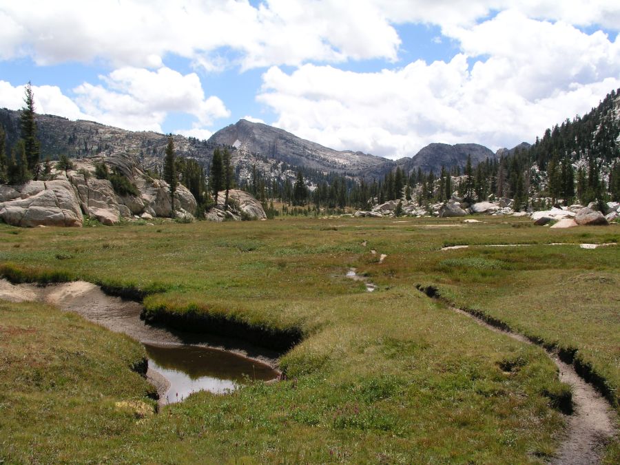
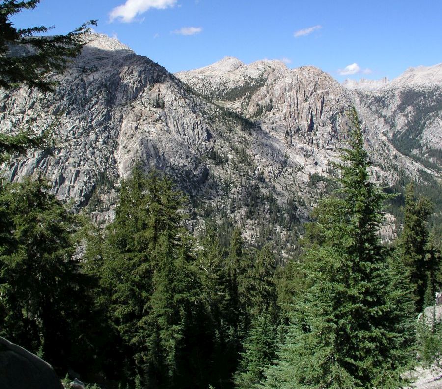
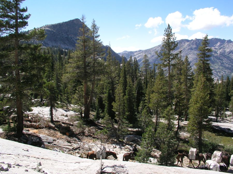
Experience a section of Yosemite National Park that few visitors see. You will enter Yosemite from the east side of the Sierra, at Virginia Lakes, to cross the Sierra Crest into Yosemite National Park. Your path will lead you past expansive views, powerful waterfalls, cascading creeks, dense pine forests, and lush meadows as you travel through the granite peaks and glacial valleys of northern Yosemite.
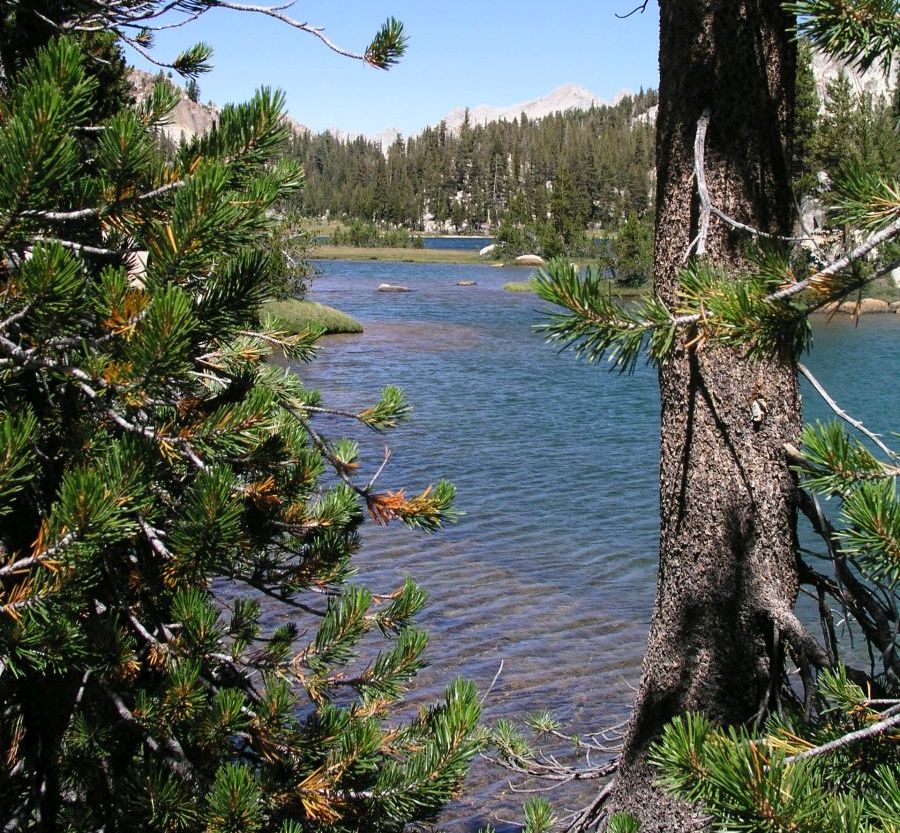
Layover days allow day trips to Miller Lake, McCabe Lakes, and Waterwheel Falls.
The trip moves through subalpine forest and the alpine zone. Expect to see western white pine, mountain hemlock, and lodgepole pine with many subalpine meadows that flower from July through August. The alpine zone of Yosemite begins near the 9,500-foot elevation. No trees grow in this zone due to the short, cool summers with long, cold, and snowy winters that are typical at these elevations. Many exposed granitic outcroppings, talus slopes, and boulder fields limit the amount of vegetation that grows here.
The above information is taken from the Yosemite National Park website. Select Learn About the Park>Nature> and then the topics you are interested in to learn more. https://www.nps.gov/yose/index.htm
Itinerary:
Day 1: Virginia Lakes to Virginia Canyon
9.2 miles, 1,550 gain, 2,650 loss
The trail follows the north side of Blue Lake and then climbs fairly steeply in open forest to Cooney Lake in the first mile. The trail climbs 750 past the Frog Lakes on shale slopes to a saddle at mile 2.6. The rocky path descends steeply to the Green Lake Trail junction at mile four. Turn left at the junction toward Summit Lake and climb 170 in 0.4 miles to the lake. The trail drops steeply as it enters Yosemite National Park, turning into a gentle descent down through Virginia Canyon after the junction to Virginia Pass. The path down the canyon is through lodgepoles and meadows, with areas of trees downed by avalanches during high snow years. Camp is about 3.2 miles down canyon from the Virginia Pass junction.
Virginia Canyon is a destination in itself, but two layover days allow day trips to the beautiful Miller Lake and McCabe Lakes.
Day 2: Layover--Ride to Miller Lake 8.6 miles round trip
8.6 miles round trip / 4.3 miles, 1,300 gain, 500 loss to Miller Lake
The day starts with a gentle descent down Virginia Canyon to the junction of the Pacific Crest Trail at mile 0.8. The trail to the right continues down the canyon before climbing 1,000 fairly steeply up Spiller Creek to a saddle at mile 4.6. Wonderful views to the west open up as the trail undulates another 1.4 miles to Miller Lake. The lake is shallow which makes it a good swimming lake. There are wonderful views across the canyon of the Tuolumne River as far as the Cathedral Range to the south from near the outlet of the lake or the low dome to the west of the lake. Return to camp by the same route.
Day 3: Virginia Canyon to Happy Jack
It is about a 5 mile ride to the beautiful meadows in Upper Cold Canyon.
Day 4: Layover--Ride to McCabe Lakes
The McCabe Lakes are beautiful gems. The ride to the lakes will be between 1 ½ hr to 2 hrs with plenty of time to fish and explore the upper lake.
Day 5: Happy Jack to Glen Aulin
A short five mile move to Glen Aulin. Time permitting, the group will ride down to view waterwheel Falls. It is about two miles from Glen Aulin to a great viewpoint to see the Falls.
Day 6: Glen Aulin to Tuolumne Meadows
The ride out is about 6 to 7 miles. Spectacular vistas of Cathedral Peak and of Tuolumne Meadows. Arrival around 1 to 2pm. Riders are transported back to Tuolumne Meadows.
Please note that this represents the planned itinerary. Weather or other factors may affect the choice of campsites and daily travel. All decisions are made by the Head Packer with attention to the safety and comfort of guests and stock.
What you need to know
for riders
(TRAIL RIDE, ALL EXPENSE, AND BASE CAMP INFORMATION)
OUR SERVICES
We supply horses, saddles, food, kitchen and eating utensils, and camping equipment. Dormitory tents will be provided for men and women. Private tents for couples or singles will be reserved by request. Food will be plentiful and deluxe in quality. We provide the preparation of meals; any help is appreciated but not mandatory. Those desiring to learn how to pack may participate in making up loads and packing the mules.
IMPORTANT INFORMATION
- Check-in time is 7 a.m. at Rock Creek Pack Station except when OTHER LOCATION is specified.
- Free parking for guests' cars at pack station.
-
Breakfast is served the first day while the mules are being loaded.
The last meal furnished is lunch the last day.
- We provide a small saddle bag for trail necessities. Please do not bring your own saddle bags or day packs unless they
are pocket size. Participants may not carry large camera
cases with extra lenses on the saddle. If you have extra camera equipment, it can be packed in your duffel or in a
safe place on mules.
-
You will be limited to 3 lbs. in the saddle bag, which includes your lunch.
Your jacket and rain gear are not included in the 3 lbs. and may be tied on the back of the saddle. No day packs allowed on riders' backs.
- Each person is assigned a horse for the duration of the trip with regard to the guest's weight, height, and ability.
- Dunnage limit is 30 lbs. per person (this includes sleeping bags, fishing equipment, liquor, etc.).
There will be a surcharge of $3 to $10 per pound on dunnage in excess of the 30 lbs. You may bring your own tent if under 10 lbs. which will not be included in 30 lb. weight limit.
- Trip fee does not include alcoholic beverages or lodging night before and after trip.
- Gratuities are optional and a personal choice.
- Trip will terminate in the late afternoon of last day.
- Free shuttle back to Rock Creek Pack Station for trips terminating at other road heads.
- Reservation form must be accurately completed.
The information on age, height, weight and riding ability is used to assign riding animals. Failure to provide accurate information may result in the participant being denied going on the trip with loss of trip fee.
- We advise guests to purchase cancellation and trip travel insurance.
- Participants will be sent an assumption of risk and a liability release form. All guests must assume the risk and sign the forms before using Rock Creek's service. Our forms have excellent guidelines for riding safety that we ask you to study.
- The pack station does not boil or treat water. Campsites are remote enough that we feel safe in using the water. It you want to purify water bring your own filter pump or purification tablets.
PERSONAL CHECK LIST
Bring belongings in stout canvas or nylon duffels; side zipper recommended, ideal size approximately 14" x 32".
It is a good idea to use a large plastic bag INSIDE of the duffle to protect contents from external moisture.
Sleeping bags can be in separate duffels --again, line the inside of the duffle against rain.
Place all cosmetics, soaps, medications, etc into small plastic containers with close-fitting caps,
THEN into sturdy resealable plastic storage bags.
If anything breaks or bursts from altitude changes, the plastic bag contains the spill.
When possible, it is a good idea to transfer alcoholic beverages to sturdy plastic bottles with well fitting caps - it will save weight and protect against breakage.
Check in fishing worms and bottle goods separately; don't put in duffel. Place fishing rods in metal or plastic cases.
You will be given a small saddle bag that goes on your saddle horn to carry your lunch and a few personal items. (Weight limit 3 lbs - including lunch).
Remember - try to minimize the weight of your dunnage by packaging only
the amount of any item you will need (like soaps, lotions and medications).
RECOMMENDED ITEMS:
- Sleeping bag with a comfort range of 20 to 60 degrees and a moisture proof ground cloth.
- Air mattress or small 1/4"-1/2" foam hip pad recommended - your night's rest will affect your next days enjoyment.
Bring the best sleeping pad you can manage.
- Broad-brimmed hat is essential for protection from sun at high altitude. It must have strings to keep from blowing off.
- Sunglasses (RX glasses) - high altitude sun is BRIGHT!
- Coffee mug (plastic for camp)
- Pint water bottle for your horn bag
- Pocket knife or small multi-tool
- Flashlight and extra batteries
- Camera and film (sturdy strap)-- if using digital - don't forget an extra battery and card
- Rain jackets and pants or slicker (rolled up you can tie them to the back of your saddle)
- Hat protector (to keep your hat dry)
- Light jacket (windbreaker)
- Wool or fleece pullover/sweater (layers will keep you comfortable)
- Heavy jacket
- Bandana
- Woolen cap (evenings can be cold)
- Gloves (recommend gloves for riding, may want warm gloves for evenings)
- Socks
- Riding boots
- Shoes for camp (moccasins, athletic shoes, etc)
- Shirts and pants (long sleeved shirts offer sun, bug and branch protection)
- Underwear
- Bathing suit
- Bath towel/wash cloth/soap (try a multi-use bar or liquid for use on hair, body and laundry. Biodegradable choices are available.)
- Insect repellent such as Cutters
- Toothbrush/toothpaste
- comb/brush clips/pins/ponytail holders
- Shaving kit (a small mirror is helpful)
- Sun Screen (lotion, cream or stick)- use liberally for sunburn and chapping prevention.
- Chapstick with sun protection SPF 15 or better
- Moisturizer (cream or lotion - altitude and sun can be dry and chap skin)
- Prescription medicine (if required - if you have any allergies, remember to bring appropriate medication)
- Band-aids, aspirin, ibuprofen, eye drops, moleskin for any blisters
- Baby powder/Talcum powder (helps to relieve any raw or irritated areas from boots, clothes or saddles)
- Kleenex
- Jogging suit (sweats are comfortable for after-swim and campfire lounging)
OPTIONAL ITEMS:
- Small notepad and pencil
- Collapsible plastic wash basin (optional)
- Solar shower (optional)
- Water filtering pump (optional)
- Liquor (be sure to check in with the packers to see that your liquor is packed safely)
- Fishing equipment (optional)
- CALIFORNIA FISHING LICENSE. Please note that fishing licenses are NOT available at or near the pack station. Be sure to get one BEFORE you arrive for your adventure. You can find information on California fishing licenses and online purchase at TakeMeFishing.org. You can purchase them at a Bishop sporting goods store, as well.
- Rod/reel/line (a rod that breaks down into 3 or more pieces is recommended)
- Compact metal rod case to carry on saddle
- Canvas creel (no tackle boxes)
- Leader material (1-3 lb.)
- Flies: black gnat, mosquito, grey hackle, brown hackle, & royal coachman (No. 12-14 hooks)
- Bait: worms & Pautzke red eggs
- Egg hooks, worm hooks (No. 10-14)
- Split shot
- Lures (personal choice)
- Pliers
LOW-IMPACT GUIDE FOR THE WILDERNESS USER
We are dedicated to conducting our trips so that others following us will find the country unspoiled. Livestock is a natural part of the wilderness and when properly managed enhances man's enjoyment of our unmechanized wilderness area. Today, just as it was when the entire west was mostly wilderness, the horse and mule remain our companions and servants in wilderness travel. We practice and expect you to observe the following during your trip.
- Keep horses on trail; do not cut switchbacks (corners).
- Tie horses 200 feet away from streams, trails and campsites. At camps, horses and mules are tied to picket lines,
stretched between trees on granitic soil.
- If you can't tie animal to picket line use a tree greater than 8" in diameter, not on grass. Tie high and short (2-3 ft.) so horse doesn't get foot caught in rope.
- Choose a tent site at least 100 ft. from water (THE LAW) where drainage will not be a problem, avoiding the need to trench. No tents or camp area allowed on grass or meadowlands.
- Utilize pre-existing fire rings where possible. Don't surround fires with rocks! Dig a hole in sand and cover when finished. When you leave camp, bury ashes from fire rings. Leave existing fire rings clean for the next user.
- When breaking camp, return the spot to its natural state and broadcast a covering of needles and cones. Scout the area to make sure nothing will be left behind. Remove the smallest pieces of aluminum foil and trash.
- Pack out all trash. Don't bury garbage, scatter organic wastes or leave foil in campfire pit. Burn cans and flatten. On our group trips we have a bag for cans and aluminum foil.
- Don't use soap (even biodegradable) in streams or lakes, Wash yourself, clothes and dishes away from water sources.
- Bury human waste 200 ft. from water, campsites and trails. Dig a hole 4-6" deep and after use tamp with sod.
- Don't pick flowers or cut branches from live trees. Use only downed wood for fires.
- You are required to keep bears from getting to your food at all times. Please ask for current regulations and suggestions on how to prepare for your trip.
You can purchase quality topo maps at TOM HARRISON MAPS.
Tom Harrison Hoover Wilderness Map, paper or download onto phone/tablet. A short section of the trail missing from the map includes Miller Lake, which is on the Yosemite High Country map.
National Geographic 308 Yosemite NE: Tuolumne Meadows and Hoover Wilderness Trail Map
Apps for Smartphone/Tablet, download applicable areas prior to departure: