Hikers should be able to walk 12 miles, 3,000 elevation gain and loss. You should acclimate to at least 8,000 to 10,000 for 1-3 days prior to the trip.
Distance: 36 miles with a total gain of 6,450 feet, and a total loss of 9,200 feet.
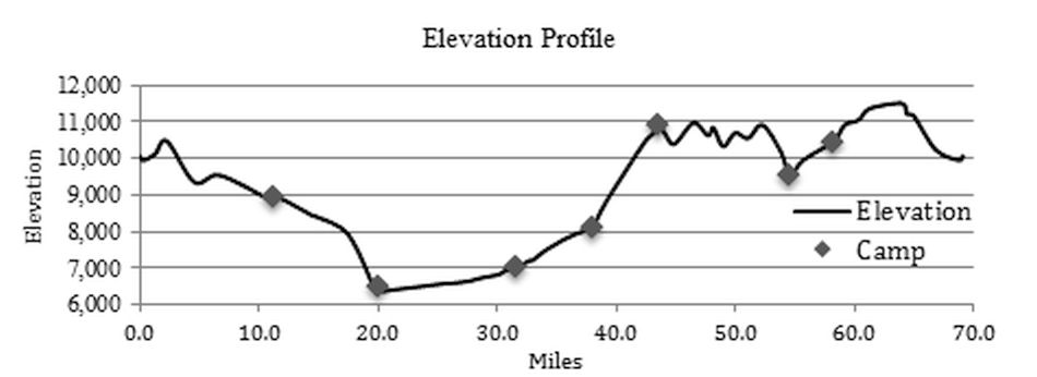
Elevation Profile:
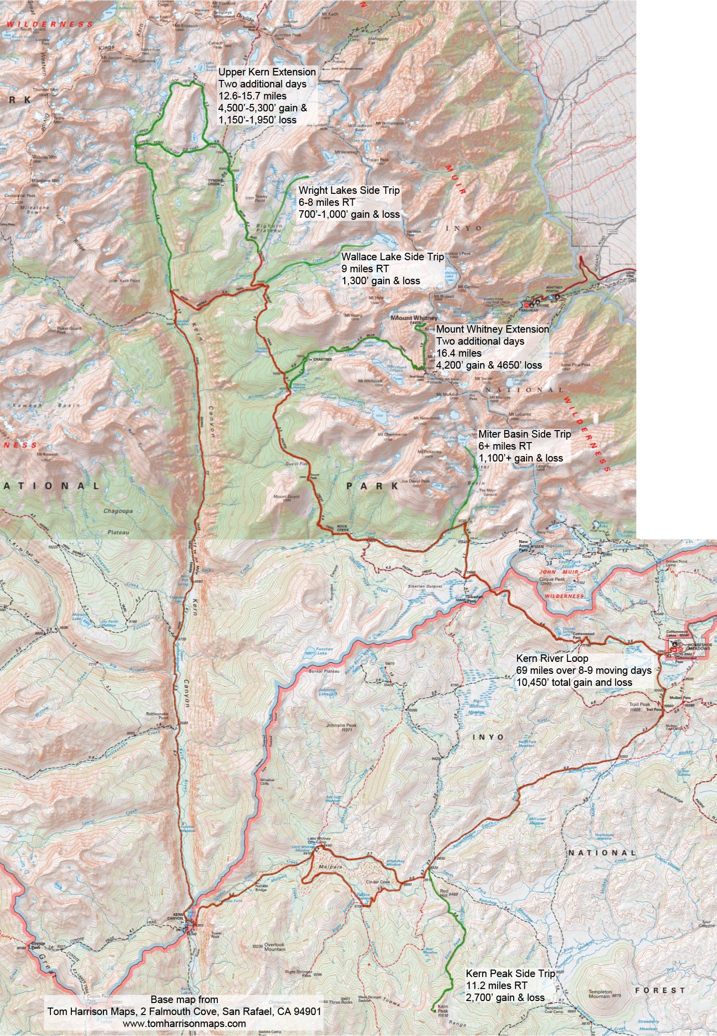
69.3 miles, 10,460 total gain and loss on moving days
GENERAL:This trip requires many stream crossings and some may require wading. Hikers should be prepared with trekking poles as well as sandals or water shoes to ford creeks.
Moving Day 1: Horseshoe Meadow over Trail Pass to Golden Trout Creek
11.2 miles, 1,035 gain, 2,200 loss
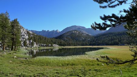
The path drops 100 from the pack station to the junction with the Cottonwood Pass trail. Continue straight toward Trail Pass to cross Horseshoe Meadow toward Trail Pass. In one mile, the path will merge with a trail running along the east side of the meadow is it continues up 600 through forest to 10,500 Trail Pass and the junction with the Pacific Crest Trail. Enjoy views of the Golden Trout Wilderness before continuing straight, to drop 1,150 in 2.3 miles through open forest to the trail junction at Mulkey Meadow, a favorite lunch spot. Turn right at the Mulkey Pass/Tunnel Meadow trail junction toward Tunnel Meadow. The trail skirts the northern edge of Bullfrog Meadow before climbing a low ridge and then descends along the South Fork of the Kern River, our first native golden trout creek, along Tunnel Meadow. Watch for the abandoned airstrip as you pass through the meadow and an unnatural dip in the trail at the end of the meadow where it crosses a collapsed tunnel dug in the 1880s to divert water from Golden Trout Creek into the South Fork of the Kern River. Go straight toward Little Whitney Meadow at the Golden Trout Creek Trail junction at mile 10.6. In another 0.3 miles, stay to the right at the Ramshaw Meadow junction and then watch for camp on the left within 0.3 miles as you approach the Bear Meadow junction.
Water is readily available from Mulkey Meadow to camp in normal water conditions.
Moving Day 2: Golden Trout Creek to Little Whitney Meadow
When one thinks of the Sierra, one thinks of granite peaks. The uplift that brought the granite to the surface also created pathways for magma to reach the surface, creating volcanic cones and basalt flows. Both routes, listed below, pass by the Groundhog Cinder Cone and miles of ancient basalt flows on their way to Little Whitney Meadow.
Via Groundhog Meadow (route 1)
3.9 miles, 25 gain, 525 loss.
This short, relatively flat day offers anglers the opportunity to fish Golden Trout Creek. Return to the Little Whitney Meadow trail and turn left. Go to the right at the Volcano Meadow junction, mile 0.6, always following the trail signs to Little Whitney Meadow. The path follows Golden Trout Creek through Groundhog Meadow and past Cinder Cone and ancient lava flows before arriving at Little Whitney Meadow. Cross the meadow from the junction or navigate around the end of the meadow to our camp on the west side of the meadow. Watch for the rustic cabins of the historic Little Whitney Cow Camp at the north end of the meadow.
Via Volcano Meadow (route 2)
6.2 miles, 600 gain, 1,000 loss.
An alternate route is through Volcano Meadow. According to the California Department of Fish and Wildlife, The Volcano Creek strain of California golden trout is considered to be the most genetically pure population within the native range. This infrequently visited area of the Golden Trout Wilderness offers spectacular views and a high probability of wildlife sightings. Due to the lack of visitors and fishing pressure, the beautiful golden trout of Volcano Creek are plentiful and willing to bite.
Return to the Little Whitney Meadow trail and turn left. In another 0.6 miles, at the Volcano Meadow junction, turn left onto the lightly used Volcano Meadow trail. Cross Golden Trout Creek and then climb 300 over the saddle to the south of Cinder Cone before dropping 450 to Volcano Meadow. Follow Volcano Creek almost to the junction with Golden Trout Creek before the path turns north to trace the western edge of the lava flow to the south end of Little Whitney Meadow. Cross Golden Trout Creek and travel north along the west side of the meadow to our camp.
Water is readily available throughout the day in normal water years.
Moving Day 3: Little Whitney Meadows to the Kern River
10.9 miles, 500 gain, 2,300 loss.
The route continues past signs of ancient volcanic activity. In 2.7 miles, the trail passes over a natural bridge. Geologists believe the bridge was created when mineral rich spring water heated by the slowly cooling lava flows left travertine deposits on surrounding gravel that later eroded away. The path soon begins a 1,600 descent to the Kern River. Watch for basalt columns created when the lava flow was quenched by the ice and meltwaters of the glacier that filled Kern Canyon. The path traverses a dry, dusty patch for about ¼ mile as it parallels the river south. The route finally crosses the Kern River on a bridge at mile five to a junction on the west side of the river. Turn right. A favorite lunch spot nearby is a soda spring close to the river. Watch for a path off to the right, shortly after the junction. The trail now undulates gently through forest and meadows as it follows the Kern River north for 5.7 miles to gain an additional 300 of elevation. Camp is ¼ mile below the Rattlesnake Creek crossing on the east bank of the Kern River. Anglers will have ample opportunity to enjoy the world class fishing of the Kern River.
Water is available at several creek crossings and at points along the Kern River in normal water years.
Moving Day 4: Kern River to Junction Meadow
12.2 miles, 1,800 gain, 300' loss.
The remarkably straight Kern Canyon was formed as the river followed an inactive 80 mile long fault. Glacial ice from both the Sierra Crest and the Great Western Divide merged to flow down the canyon, widening and straightening the watercourse to create a steep-walled canyon several thousand feet deep. Our route continues up this canyon, following the Kern River to Junction Meadow. Anglers will enjoy exceptional fishing along the route.
The day starts by fording the Kern River to rejoin the trail and then crossing Rattlesnake Creek in ¼ mile. Go straight at the Rattlesnake Creek junction to follow the Kern River. The path continues through forest and across meadows crossing Big Arroyo on a bridge at mile 1.8 and arriving at the High Sierra Trail Junction at mile 2.9. Continue straight to join the High Sierra Trail, crossing Funston Creek and then Chagoopa Creek at mile 3.9, before crossing the Kern River on a bridge at mile 4.3.
The Kern Hot Springs are 0.4 miles past the bridge crossing. After a nice soak in the hot springs, continue an additional 7.5 miles up the steep-walled canyon through forest and meadows, crossing numerous streams, to our camp at Junction Meadow.
This is a long day that can be divided into two days by camping near the Kern Hot Springs.
4.7 miles, 450 gain, 150 loss
7.5 miles, 1,350 gain, 150 loss
Water is readily available at numerous creek crossings in normal rain years.
Moving Day 5: Junction Meadow to Wright Creek
5.6 miles, 2,800 gain, 50 loss
We have travelled along the bottom of Kern Canyon for two days. Today, the trail climbs up the east wall of the canyon, offering views down the U-shaped valley. Go to the right at the Colby Pass junction to climb out of the forest through manzanita-covered terrain to the Kern River Trail junction, mile 1.2. Turn right to follow Wallace Creek up 1,600 in 3.1 miles, first through manzanita-covered slopes and eventually into open forest and meadows to the junction of the John Muir Trail. Turn left onto the JMT to ascend a 250 ridge in 0.4 miles and then climb gently through open forest for another mile to our camp at the edge of Wright Meadow with stunning view of the Sierra Crest.
We recommend spending at least one layover day at the Wright Creek camp to enjoy the beauty of the area and fish Wallace Lake or the Wright Lakes. See the Layover Day Trips in the next section for a detailed description.
Water is available at the Wright Creek crossing below the JMT junction, at the JMT junction, and at the Wright Creek crossing on the JMT.
Moving Day 6: Wright Creek to Lower Rock Creek
11 miles, 1,750 gain, 3,100 loss
Return to the John Muir Trail, turning south toward Wallace Creek. The path crosses the creek and climbs 600 in 1.6 miles before dropping gently to skirt Sandy Meadow and then ascends a 200 ridge to the junction with the Pacific Crest Trail. Go straight on the Pacific Crest Trail, dropping 400 in 0.6 miles to the Crabtree Meadow junction. Check your water here, because there is little reliable water for the next 5.6 miles. The trail climbs steadily to gain 500 in the first mile and then traverses the hillside on a sandy trail for 2.3 miles, dropping 200 before climbing 450 to Guyot Pass. Twisted foxtail pines frame views of Red Spur across the Kern Canyon. The path then drops 1,400 in 2.5 miles to Rock Creek. Camp is a short distance to the right on the north side of the creek.
There is little reliable water between the Crabtree Meadow junction and Rock Creek.
Moving Day 7: Lower Rock Creek to Upper Rock Creek
3.7 miles, 950 gain, 50 loss
Return to the John Muir Trail and go to the right to cross Rock Creek, climbing out of the drainage to the Rock Creek Trail junction in 1.1 miles. Go left at the junction to follow the creek through forest and meadows for 2.6 miles to Rock Creek Lake. Camp is in the trees at the east end of the meadow surrounding the lake.
This is a short day to allow a trip into Miter Basin. See the Layover Day Trips in the next section for a detailed description.
Water is readily available throughout the day.
Moving Day 8: Upper Rock Creek to Horseshoe Meadow
10.8 miles, 1,600 gain, 1,935 loss
Follow the trail up to the Soldier Lake junction, 400 in ½ mile. Turn right and follow the path past the junction of New Army Pass, mile 1.0, to the Pacific Crest Trail at mile 2.1. Go left at the junction toward Cottonwood Pass to travel through open forest past Chicken Spring Lake to the pass, mile 6.7. Leave the Pacific Crest Trail toward Horseshoe Meadow, dropping 1,300 in 3.7 miles to the pack station.
The only reliable water is at Chicken Spring Lake.
While the riders and packers will follow the Cottonwood Pass route, an alternate route for hikers is over New Army Pass, 12.5 miles with a 1,750 gain and 2,100 loss.
SUGGESTED LAYOVER DAY TRIPS
Safety, trail conditions, weather, group interest and other factors play a part in determining the final route for this trip. Many options exist.
UPPER ROCK CREEK CAMP
Miter Basin
6.0 miles, 1,100 gain and loss
There is an unmaintained trail that follows Rock Creek into Miter Basin from near the small lake. The trail climbs through open forest to a large meadow and then continues up the basin to a mix of slick rock and meadow where you are surrounded by 13,000-14,000 peaks, about two miles and 700 elevation gain. You can follow the drainage up an additional mile and 400 elevation gain to beautiful Sky Blue Lake. Other lake basins and Crabtree Pass (12+ miles round trip, 2,400 gain and loss) are options. Your distance depends on how far you elect to venture into the basin.
Water is readily available in Miter Basin in normal rain years.
OR
Summit Mt. Langley
11+ miles, 3,700 gain and loss
To travel to the top of Mt. Langley, return to the Rock Creek Trail trail past the Soldier Lake junction and then turn left at the junction to New Army Pass. Ascend toward New Army Pass, watching for an unmaintained trail to (Old) Army Pass on the left. Turn north and ascend the scree and gravel on the south slopes of Mount Langley. The slope gets steeper towards the end. The easiest route is found by skirting the summit plateau slightly to the left to avoid the steep rock straight ahead. Once the plateau is reached, travel straight north, and when you reach the steep North Face of Langley, turn right and head west toward the summit. The summit is an unimpressive platform of sand and rocks, but the views in all directions are amazing. Source: http://www.summitpost.org/army-pass-normal-route/156296.
Water is available to Soldier Lake and may be available part way up the New Army Pass Trail.
EXTENSIONS THAT CAN BE ADDED TO THE BASIC TRIP
UPPER KERN
Allow at least one additional day.
The Upper Kern Lake Basin can be added to the section between Junction Meadow and Wright Meadow. This remote, spectacular area is very lightly used and is known for excellent fishing. This extension deserves at least one layover day to explore Milestone Creek or the lakes of the Upper Kern.
There is reliable water from the Kern River, side streams, and lakes both days.
Day 1: Junction Meadow to Milestone Creek
5.3 Miles, 2,400 gain, 0 loss
The route to our camp near Milestone Creek is a steady climb. The trail ascends the east wall of Kern Canyon, offering great views down the U-shaped valley. Go to the right at the Colby Pass junction to climb out of the forest through manzanita covered terrain to the Kern River Trail junction, mile 1.2. Follow the Upper Kern River trail to the left. The route follows the river north, passing an abandoned cabin before crossing Tyndall Creek at mile 1.9. The trail follows the Kern River, moving in and out of open forest before entering a wildflower and fern filled dell and soon arriving at our camp near the confluence of the Kern River and Milestone Creek.
Day 2: Milestone Creek to Wright Meadow
Option 1 Via Upper Kern Loop Trail (Lake South America)
10.4 miles, 2,900 gain, 1,950 loss
The trail follows the Kern River, rising steeply 600 in the first ½ mile before ascending more gently across slick rock to the junction with the Upper Kern Cut-Off Trail. The path continues straight toward Lake South America across open terrain passing along the eastern edge of five lakes as it ascends 1,300 in 3.1 miles to the spur trail to Lake South America. Go left for 0.2 miles to the outlet of the lake. To continue the route, return to the Upper Kern Loop Trail and go left to climb 200 over a saddle before dropping steeply for 500 and then descending more gently along the east side of a long, rocky meadow to the eastern junction of the Upper Kern Cut-Off Trail. Go left to descend 350 in 0.6 miles to the junction with the John Muir Trail. Turn south to cross Tyndall Creek in ¼ mile and then climb 600 over 1.6 miles to expansive views from Bighorn Plateau before descending for a mile to our camp at the edge of Wright Meadow.
Option 2 Via Upper Kern Cut-Off Trail
7.3 miles, 2,100 gain, 1,150 loss
The trail follows the Kern River, rising steeply 600 in the first ½ mile before ascending more gently across slick rock to the junction with the Upper Kern Cut-Off Trail. Go right to climb 700 in two miles across sections of meadow and rock to a ridge with spectacular views of the Great Western Divide. The route then drops down a rocky trail for 0.6 miles to the eastern junction of the Upper Kern Loop Trail. Continue straight to descend 350 in 0.6 miles to the junction with the John Muir Trail. Turn south to cross Tyndall Creek in ¼ mile and then climb 600 over 1.6 miles to expansive views from Bighorn Plateau before descending for a mile to our camp at the edge of Wright Meadow.
MOUNT WHITNEY
Allow one additional day. Summiting Mount Whitney can be added to the trip section between Wright Meadow and Rock Creek. Day 1 replaces Moving Day 6 and Day 3 replaces Moving Day 7.
Day 1: Wright Creek to Guitar Lake
8 miles, 1,800 gain, 1,150 loss
Return to the John Muir Trail, turning south toward Wallace Creek. The path crosses the creek and climbs 600 in 1.6 miles before dropping gently to skirt Sandy Meadow and then ascends a 200 ridge to the junction with the Pacific Crest Trail. Go left to follow the John Muir Trail toward Mount Whitney. Continue straight in 0.8 miles at the Crabtree Meadow junction, leaving the trees at Timberline Lake and finally stopping at our camp above Guitar Lake. Mount Whitney towers 3,000 above the lake to the east.
Day 2: Guitar Lake to Mount Whitney and Crabtree Meadow
12.6 miles, 3,300 gain, 4,350 loss
There is no reliable water between Guitar Lake and the top of Mount Whitney.
Day 3: Crabtree Meadow to Upper Rock Creek
10.4 miles, 1,850 gain, 1,900 loss
Follow the trail 0.6 miles to the junction with the Pacific Crest Trail. The trail climbs steadily to gain 500 in one mile and then traverses the hillside on a sandy trail for 2.3 miles, dropping 200 before climbing 450 to Guyot Pass. Twisted foxtail pines frame views of Red Spur across the Kern Canyon. The path then drops 1,400 in 2.5 miles to cross Rock Creek before ascending 400 in 1.3 miles to the Rock Creek Trail junction. Go left at the junction to follow the creek up through forest and past meadows to the Rock Creek Lake and Stringer Meadow. Camp is at the east end of the meadow.
There is no reliable water between Crabtree Meadow and the Lower Rock Creek crossing. Water is readily available for the balance of the day.
DISTANCES AND ELEVATIONS
| Location | Daily
Distance | Cumulative
Distance | Elevation |
| Cottonwood Pack Station/Horseshoe Meadows | | 0.0 | 10,065
|
| Cottonwood Pass/Trail Pass Junction | | .3 | 9,950
|
| Junction from Eastern Trailhead | | 1.3 | 10,120
|
| Trail Pass | | 2.3 | 10,472
|
| Templeton Meadows Trail Junction | | 4.6 | 9,350
|
| Big Whitney Meadows Trail Junction | | 10.6 | 8,930
|
| Ramshaw Meadows Junction | | 10.9 | 8,920
|
| Golden Trout Creek Camp | 11.2 | 11.2 | 8,910
|
| Bear Meadow Junction | | 11.4 | 8,910
|
| Volcano Meadow Junction | | 12.0 | 8,915
|
| Johnson Creek Trail Junction | | 14.7 | 8,440
|
| Little Whitney Meadow Camp | 3.9 | 15.1 | 8,400
|
| Natural Bridge | | 17.8 | 7,900
|
| Kern River Bridge | | 20.1 | 6,300
|
| Ranger Station | | 20.3 | 6,455
|
| 21 Inch Camp/Rattlesnake Creek | 10.9 | 26.0 | 6,580
|
| Rattlesnake Creek Crossing | | 26.2 | 6,580
|
| Rattlesnake Creek Trail Junction | | 26.2 | 6,580
|
| Big Arroyo Creek | | 27.8 | 6,640
|
| High Sierra Trail Junction | | 28.9 | 6,730
|
| Kern River Bridge | | 30.3 | 6,820
|
| Kern Hot Springs | | 30.7 | 6,880
|
| Whitney Creek Crossing | | 36.0 | 7,840
|
| Wallace Creek Crossing | | 37.9 | 8,030
|
| Junction Meadow Junction | 12.2 | 38.2 | 8,080
|
| Upper Kern Junction | | 39.4 | 8,830
|
| John Muir Trail Junction | | 42.5 | 10,405
|
| Wright Creek Crossing | | 43.3 | 10,680
|
| To Wright Meadow Camp | 5.6 | 43.8 | 10,880
|
| Wallace Creek Crossing | | 45.1 | 10,395
|
| Whitney JMT/PCT Split | | 48.5 | 10,774
|
| Crabtree Meadow Junction | | 49.2 | 10,332
|
| Guyot Pass | | 52.5 | 10,915
|
| Lower Rock Creek Camp | 11.0 | 54.8 | 9,536
|
| Upper Rock Creek Junction | | 55.9 | 9,949
|
| Miter Basin Junction | | 58.4 | 10,445
|
| Upper Rock Creek Camp | 3.7 | 58.5 | 10,400
|
| Soldier Lake Junction | | 59.0 | 10,720
|
| New Army Pass Junction | | 59.5 | 10,940
|
| Pacific Crest Trail Junction | | 60.6 | 11,060
|
| Sequoia National Park Boundary | | 61.5 | 11,366
|
| Chicken Springs Lake Outlet Creek | | 64.6 | 11,220
|
| Cottonwood Pass | | 65.2 | 11,160
|
| Trail Pass Junction | | 69.0 | 9,950
|
| Cottonwood Pack Station/Horseshoe Meadow | 10.8 | 69.3 | 10,065
|
Please note that this represents the planned itinerary. Weather or other factors may affect the choice of campsites and daily travel. All decisions are made by the Head Packer with attention to the safety and comfort of guests and stock.
EXPECTED CAMPSITE LOCATIONS
| Day | To | Elevation | Latitude N | Longitude W | Miles | Gain | Loss |
| 1 | Rock Camp | 8,910 | 36.359 | 118.292 | 11.2 | 1,035 | 2,200 |
| 2 | Little Whitney Meadow | 8,400 | 36.373 | 118.348 | 3.9 | 25 | 525 |
| 3 | 21 Inch Camp | 6,600 | 36.418 | 118.410 | 10.9 | 500 | 2,300 |
| 4,5 | Junction Meadow on the Kern | 8,100 | 36.578 | 118.414 | 12.2 | 1,800 | 300 |
| 6 | Wright Creek | 10,850 | 36.606 | 118.370 | 5.6 | 2,800 | 50
|
| 7 | Lower Rock Creek Crossing Meadow | 9,500 | 36.500 | 118.336 | 11.0 | 1,750 | 3,100 |
| 8 | Rock Creek Lake and Stringer Meadow | 10,400 | 36.495 | 118.280 | 3.7 | 950 | 50 |
| 9 | Cottonwood Pack Station | 10,065 | 36.451 | 118.172 | 10.8 | 1,600 | 1,935 |
| | Total | | | | 69.3 | 10,460 | 10,460 |
*Mileage, gain, and loss based on Guthooks PCT Guide.