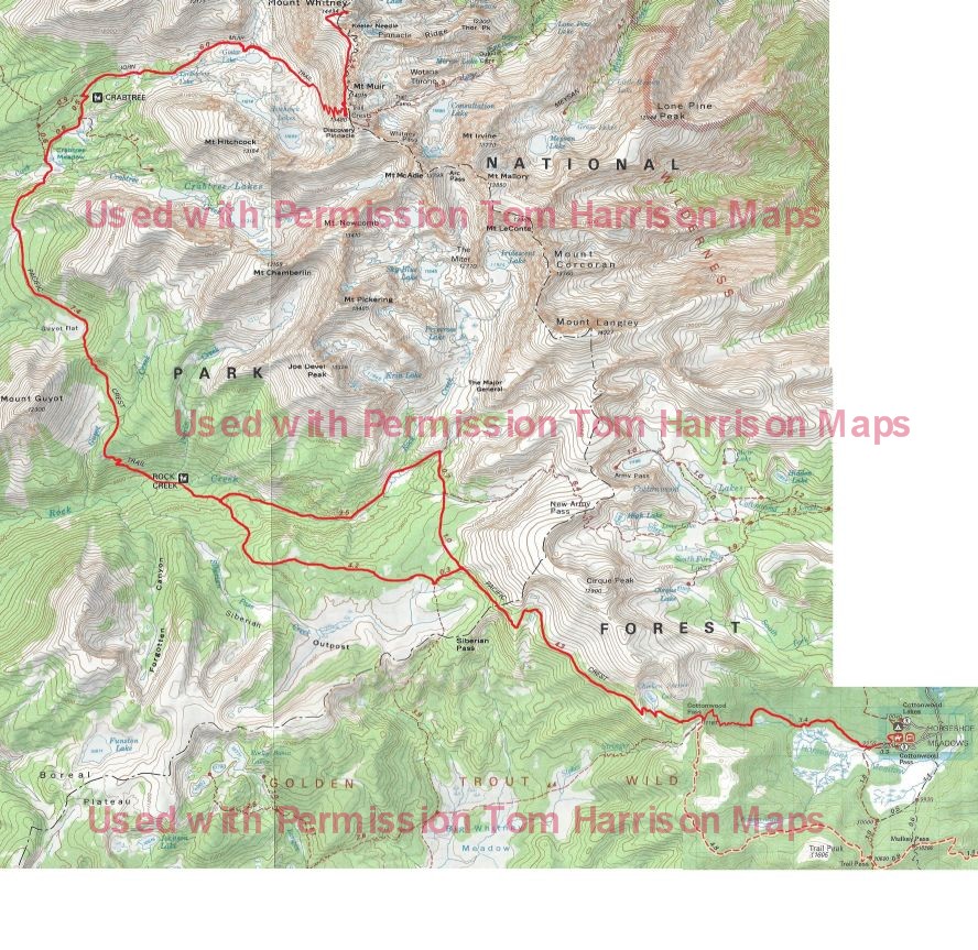
Hikers should be able to walk 12 miles, 3,000 elevation gain/loss. You should acclimate to at least 8,000 to 10,000 for 1-3 days prior to the trip.
Day 1: Horseshoe Meadow over Cottonwood Pass to Chicken Spring Lake
4.5 miles, 1,400 gain, 100 loss
The day will start with a 6:00 breakfast at 245 Rocking K Road, Bishop, and then the two-hour ride to the Horseshoe Meadow trailhead. The walk begins as a gentle ascent beside the meadow for a mile before entering open forest to climb steadily to 11,160 Cottonwood Pass by mile 3.8. We will turn north onto the Pacific Crest Trail, walking another half mile before leaving the trail to follow the creek a short distance up to Chicken Spring Lake.
There is no reliable water beyond Horseshoe Meadow until Chicken Spring Lake.
Day 2: Chicken Spring Lake to Rock Creek
9.8 miles, 600 gain, 2,300 loss
Returning to the Pacific Crest Trail, the path climbs briefly, gaining 300 in the first mile and then undulates along the side of the mountain with good views of Big Whitney Meadow to the left. The trail enters Sequoia National Park in three miles, dropping steadily through open forest the rest of the day, passing the Siberian Pass junction at mile four and the Upper Rock Creek Trail junction at mile 8.5. The path will finally cross Rock Creek and then leave to follow a use path down the north side of the creek to our camp alongside a beautiful meadow edged by the creek. The creek crossing might be tricky if there has been recent rain.
Most of the seasonal streams in this area will be dry with no reliable water until we approach Rock Creek at the end of the day. Be sure to leave Chicken Spring Lake with plenty of water.
Day 3: Rock Creek to Guitar Lake
9.7 miles, 3,050 gain, 1,050 loss
The day starts with a steady climb out of the Rock Creek drainage to Guyot Pass, 1,400 in 2.5 miles. Dropping down from the pass, the path traverses the hillside on a sandy trail. Twisted foxtail pines frame views of Red Spur across the Kern Canyon. There is a brief climb into the Whitney Creek drainage, before the trail drops 400 to the Whitney junction near the creek, which is about six miles from our camp. Turn onto the trail to Whitney, following Whitney Creek and passing the ranger station before joining the John Muir Trail in 1.1 miles. Turn up the canyon toward Mount Whitney, passing out of the trees at Timberline Lake and finally stopping at our camp above Guitar Lake. Mount Whitney towers 3,000 above us to the east.
There is fairly reliable water about a mile out of camp, with the next reliable water at Whitney Creek, 6 miles from the Rock Creek camp.
Day 4: Mount Whitney
9.2 miles, 3,100 gain, 3,100 loss
Mount Whitney provides several hours of shade after sunrise making the long climb to the top in the treeless landscape less daunting, so plan to leave camp at dawn. The trail starts off to the southeast for about a mile before starting to climb the steep wall on long switchbacks. Look across Hitchcock Lakes to Mount Hitchcock to gage your progress up the mountain, as Trail Junction, at 13,484 feet, is only 300 above Mount Hitchcock. Go left at the junction to follow the fairly narrow trail cut into the rock on the west side of the pinnacles. There are several windows providing stunning views to the east. Another 1.9 miles and 1,000 elevation gain takes you to the top. Enjoy your time at 14,496.81 feet before leaving the crowd at the top and returning to your wilderness camp at Guitar Lake.
There is no reliable water between Guitar Lake and the top of Mount Whitney.
Day 5: Guitar Lake to Tyndall Creek Frog Ponds
10.5 miles, 1,700 gain, 2,200 loss
The path returns 2.6 miles down the trail past Timberline Lake to the junction at Lower Crabtree Meadow, but this time follows the John Muir Trail to the right for 0.8 miles to merge with the Pacific Crest Trail. The trail soon skirts the east side of Sandy Meadow with views to the west of Red Spur, then climbs a low ridge before dropping down to Wallace Creek, which can usually be crossed on rocks. The creek runs through an open meadow surrounded by pines and the crossing is a pleasant lunch spot at 6.8 miles. Continue north past the Kern River junction to climb up a ridge to meadows of Wright Creek with stunning views to the east of the Sierra Crest including Mount Whitney. The 1,000 ascent out of Wallace Creek tops out at the treeless Bighorn Plateau with views of the Kaweah Range and the Kern River Basin to the west before dropping down to our camp at the frog ponds near Tyndall Creek.
There is reliable water at Wallace Creek and Wright Creek.
Day 6: Tyndall Creek Frog Ponds over Forester Pass to Bubbs Creek
11.9 miles, 2,300 gain, 3,350 loss
The trail drops ½ mile down through open forest to the Tyndall Creek crossing and then starts the 2,300 climb over 4.4 miles to the top of 13,180 Forester Pass, the highest pass on the John Muir and Pacific Crest Trails. The path begins through alternating forest and meadows. The landscape becomes more austere as the trail approaches and is cut from the headwall of the Kings Kern Divide. The last mile switchbacks up the right side of the pass before crossing over to the left side with tight switchbacks over the final grade. One is rewarded at the top with spectacular views of the Great Western Divide, the Kaweah Range, and the tall peaks north of Mount Whitney. Turning north, the trail enters Kings Canyon National Park, dropping down steep switchbacks. The rocky terrain gives way to forest with the final few miles a pleasant walk along Bubbs Creek to Vidette Meadow.
Day 7: Bubbs Creek to Charlotte Lake
4.2 miles, 1,250 gain, 800 loss
The trail continues to follow Bubbs Creek to the lower meadow before turning north to climb 1,200 in almost two miles to the Charlotte Lake Junction. Turn off the John Muir Trail to drop 1.3 miles to a comfortable camp near the outlet of Charlotte Lake.
Day 8: Layover at Charlotte Lake
The layover day provides time to fish and swim in the lake, do a bit of laundry, and rest your legs after a week of hiking.
Day 9: Meadow Charlotte Lake over Glen Pass to Arrowhead Lake
7.7 miles, 1,750 gain, 1,850 loss
We will backtrack 1.3 miles to the John Muir Trail junction before turning north toward the narrow ridge of 11,978 Glen Pass. The day will start in forest, but soon climbs out of the shade to rocky slopes as it approaches the pass. You will pause at the top to celebrate the climb, but you will stay to enjoy the spectacular view. Eventually drop down from the pass for lunch at the beautiful Rae Lakes and on to our camp by Arrowhead Lake.
Upper Rae Lake at mile 5.5 is the first reliable water source.
Day 10: Arrowhead Lake to Twin Lakes
9.1 miles, 2,100 gain, 1,850 loss
We will spend the first half of the day walking 4.6 miles down a pleasant trail through forest and occasional meadows to Woods Creek. We can keep an eye out for one of Shortys cabins off to the right just before we reach the creek. Crossing a suspension bridge at 8,492, we turn right and start back up through mostly forested slopes to 10,600 in almost four miles. This is a quiet day after the excitement of Mount Whitney, Forester Pass, and Glen Pass, but the views and sounds of cascading creeks surrounded by rocky canyon walls make this a great day of hiking.
There are several creek crossings along Woods Creek with reliable water.
Day 11: Twin Lakes over Pinchot Pass to the South Fork of the Kings River
7.6 miles, 1,500 gain, 2,100 loss
The hike starts near tree line, so most of this day will be walking in open alpine meadows and rocky slopes surrounded by multicolored rock walls along the way to 12,130 Pinchot Pass. The easy descent down the north side passes a series of lakes before entering the forested area above the South Fork Kings River. The Lake Marjorie shoreline, at about mile 4.6, and the stream crossing in another ¼ mile are two great lunch spots. A side trip just before the drop to the Kings River to beautiful Bench Lake is worth the 250 drop and gain over 3.4 miles.
As the trail approaches camp, it first crosses a fast creek coming from Taboose Pass and then comes to the Kings River ¼ mile later. The camp is between the two streams and to the left, at the 10,000 level.
There are some seasonal creeks along the trail, but Lake Marjorie is the first reliable water after leaving camp.
Day 12: South Fork of the Kings River over Mather Pass to Lower Palisade Lake
9.4 miles, 2,200 gain, 1,550 loss
The trail soon leaves the forest to a series of lovely alpine meadows and finally into a barren, rocky landscape with some scattered ponds at the base of the massive wall that hides Mather Pass. A series of switchbacks ascends the last of the climb to the 12,100 pass at mile 5.5 to enjoy expansive views of the trail behind and the basin ahead. The trail drops steeply with large steps and loose rubble with views of the classic glacial walls of the Palisade drainage. The trail turns to dirt below the switchback around mile seven as it aims steadily toward the Palisade Lakes below. Be sure to stop at the creek running into the east side of the upper lake to enjoy a small waterfall, wildflowers, and a great foot soak. Camp is at the far end of the lower lake.
There are several creek crossings approaching and leaving Mather Pass for water.
Day13: Lower Palisades down the Golden Staircase to Big Pete Meadow
11.9 miles, 1,400 gain, 2,800 loss
The day starts down the much- talked- about Golden Staircase, a steep set of well-designed, tight switchbacks dropping over 1,500 in about two miles. Southbound JMT hikers usually climb this and then Mather Pass on the same day, often in blazing sun. We go down in the morning shade. The trail remains in the forest much of the day as it follows first Palisade Creek and then turns up the Middle Fork of the Kings River. Grouse Meadow is the perfect place for a quick dip and a wonderful view of spectacular Le Conte Canyon. This is a long day, but the path from the bottom of the staircase drops only 1,100 in 4.5 miles, before climbing 1300 in five miles.
Day 14: Big Pete Meadow to Lower Dusy Basin
5.7 miles, 2,054 gain, 523 loss
Begin the morning by returning 1.5 miles along the Middle Fork of the Kings River to the Leconte ranger station and the junction of the Bishop Pass Trail. Turn left to leave the John Muir Trail and switchback up first through forest and then rocky meadows with wonderful views across Le Conte Canyon. The trail climbs steadily to gain 2,000 in three miles before arriving at the beautiful meadows surrounding the lakes of lower Dusy Basin. Camp is off the trail and east of the string of small, unnamed lakes anchored by Lake 10742 below Knapsack Pass.
Day 15: Lower Dusy Basin to South Lake Trailhead
8.5 miles, 1,350 gain, 2,350 loss
This is the way to finish a stay in the Sierras. The trail climbs to Bishop Pass past lakes, rocky slopes, and alpine meadows surrounded by the magnificent peaks of Dusy Basin. The path drops down from Bishop Pass at mile 3.2 through a series of meadows and along a chain beautiful lakes to reach the trailhead near the north end of South Lake.
There is reliable water from lakes and stream crossings on the north side of Bishop Pass.
The pack station drivers will arrive by 2:30 to shuttle you back to Bishop. RCPS drivers will meet hikers at Bishop Pass Trailhead, while stock will be unloaded a couple of miles further down the road.
| Location | Daily
Distance | Cumulative
Distance | Elevation |
| Horseshoe Meadow | | 0.0 | 9,940 |
| AP Junction | | 0.3 | 9,940 |
| Golden Trout Lakes Junction | | 1.0 | 9,990 |
| Cottonwood Pass | | 3.8 | 11,131
|
| Chicken Spring Lake Junction | | 4.4 | 11,219 |
| Chicken Spring Lake Campsite | 4.5 | 4.5 | 11,266 |
| Chicken Spring Lake Junction | | 4.7 | 11,219 |
| Enter Sequoia National Park | | 7.8 | 11,365 |
| Siberian Pass Trail Junction | | 8.7 | 11,085 |
| Army Pass Trail Junction | | 13.1 | 9,949 |
| Lower Rock Creek Meadows Campsite | 9.8 | 14.3 | 9,535 |
| Guyot Pass | | 16.8 | 10,942
|
| Crabtree Meadow Junction | | 20.2 | 10,332 |
| John Muir Trail Junction | | 21.4 | 10,708 |
| Guitar Lake Campsite | 9.7 | 24.0 | 11,484 |
| Trail Crest | | 26.7 | 13,432 |
| Mount Whitney | | 28.6 | 14,504 |
| Trail Crest | | 30.5 | 13,432 |
| Guitar Lake Campsite | 9.2 | 33.2 | 11,484 |
| Crabtree Meadow Trail Junction | | 35.8 | 10,708 |
| Pacific Crest Trail Junction | | 36.6 | 10,774 |
| High Sierra Trail Junction | | 39.9 | 10,410 |
| Tyndall Creek/Frog Ponds Campsite | 10.5 | 43.7 | 11,041 |
| Tyndall Creek Junction | | 44.2 | 10,921 |
| Upper Kern Cut-Off | | 44.5 | 11,050 |
| Forester Pass | | 49.0 | 13,152 |
| Upper Bubbs Creek Campsite | 11.9 | 55.6 | 9,989 |
| Lower Vidette Meadow Junction | | 56.9 | 9,554 |
| Bullfrog Lake Junction | | 58.1 | 10,526 |
| Charlotte Lake Junction | | 58.5 | 10,747 |
| Charlotte Lake Campsite | 4.2 | 59.8 | 10,370 |
| Charlotte Lake Junction | | 61.1 | 10,747 |
| Kearsarge Pass Junction | | 61.3 | 10,771 |
| Glen Pass | | 63.3 | 11,947 |
| Sixty Lakes Basin Junction | | 65.1 | 10,565 |
| Rae Lakes Ranger Station | | 66.0 | 10,612 |
| Arrowhead Lake | | 67.4 | 10,320 |
| Baxter Pass Junction | | 68.1 | 10,219 |
| Drift Fence | | 69.3 | 9,539 |
| Baxter Meadow Campsite | 9.8 | 69.6 | 9,450 |
| Woods Creek Junction | | 73.6 | 8,550 |
| Woods Basin Junction | | 77.1 | 10,366 |
| Leave Trail to Camp | | 77.9 | 10,692 |
| Cross Country to Twin Lakes Campsite | 8.5 | 78.1 | 10,602 |
| Cross Country to Trail | | 78.3 | 10,692 |
| Pinchot Pass | | 81.3 | 12,106 |
| Bench Lake Junction | | 84.2 | 10,770 |
| Taboose Pass Junction | | 84.3 | 10,777 |
| South Fork Kings River Trail Junction | | 85.5 | 10,051 |
| Cross Country to Kings River Campsite | 7.6 | 85.7 | 10,000 |
| Cross Country to Trail | | 85.9 | 10,051 |
| Taboose Pass Trail Junction | | 86.3 | 10,193 |
| Mather Pass | | 91.4 | 12,093 |
| Lower Palisade Lake Campsite | 9.4 | 95.1 | 10,603 |
| Simpson Meadow Junction | | 102.0 | 8,035 |
| Ladder Camp | 8.8 | 103.9 | 8,300 |
| Dusy Basin Junction | | 105.5 | 8,746 |
| Leave Trail | | 109.2 | 10,800 |
| Cross Country to Lower Dusy Basin Campsite | 5.8 | 109.7 | 10,800 |
| Cross Country to Trail | | 110.2 | 10,800 |
| Bishop Pass | | 112.9 | 11,972 |
| Ruwau Lake Junction | | 115.7 | 10,800 |
| Chocolate Lakes Junction | | 116.4 | 10,720 |
| Marie Louise Lakes Junction | | 116.8 | 10,440 |
| Treasure Lakes Junction | | 117.4 | 10,240 |
| South Lake Trailhead | 8.5 | 118.2 | 9,820 |
*Distances based on Guthooks PCT Guide
Please note that this represents the planned itinerary. Weather or other factors may affect the choice of campsites and daily travel. All decisions are made by the Head Packer with attention to the safety and comfort of guests and stock.
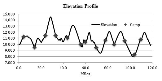
Expected Campsite Locations
| Day | To | Elevation | Latitude N | Longitude W | Miles | Gain | Loss
|
| 1 | Chicken Spring Lake | 11,250 | 36.456 | 118.226 | 4.5 | 1,400 | 100
|
| 2 | Lower Rock Creek | 9,550 | 36.496 | 118.338 | 9.8 | 600 | 2,300
|
| 3 | Guitar Lake | 11,550 | 36.572 | 118.313 | 9.7 | 3,050 | 1,050
|
| 4 | Guitar Lake | 11,550 | 36.572 | 118.313 | 9.2 | 3,100 | 3,100
|
| 5 | Tyndall Frog Ponds | 11,050 | 36.636 | 118.385 | 10.5 | 1,700 | 2,200
|
| 6 | Upper Vidette | 10,000 | 36.753 | 118.393 | 11.9 | 2,300 | 3,350
|
| 7/8 | Charlotte Lake | 10,450 | 36.778 | 118.428 | 4.2 | 1,250 | 800
|
| 9 | Baxter Meadow | 9,450 | 36.854 | 118.416 | 9.8 | 1,800 | 2,800
|
| 10 | Twin Lakes | 10,600 | 36.910 | 118.394 | 8.5 | 2,100 | 950
|
| 11 | South Fork Kings River | 10,000 | 36.969 | 118.446 | 7.6 | 1,500 | 2,100
|
| 12 | Lower Palisade Lake | 10,650 | 37.060 | 118.488 | 9.4 | 2,200 | 1,550
|
| 13 | Ladder Camp | 8,300 | 37.073 | 118.596 | 8.8 | 400 | 2,750
|
| 14 | Lower Dusy Basin | 10,800 | 37.093 | 118.562 | 5.8 | 2,500 | 0
|
| 15 | South Lake Trailhead | 9,800 | 37.169 | 118.566 | 8.5 | 1,350 | 2,350
|
| Total | 118.2 | 25,250 | 25,400 |
*Mileage, gain, and loss based on Guthooks PCT Guide.
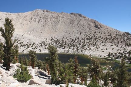 Chickenspring Lake
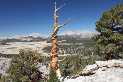 Overlooking Siberian outpost going from horseshoe meadow to Rock Creek"
 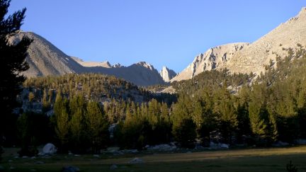 Crabtree Sunset
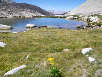 Guitar Lake
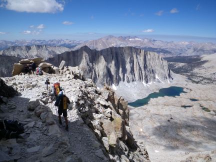
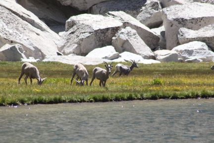 Chance for wildlife viewing at Soldier Lake...
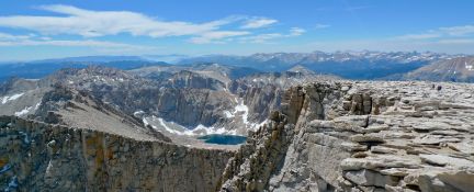
-campbell6x4.jpg) Looking Southwest from Mt. Whitney..
Looking Southwest from Mt. Whitney..